Search for articles or browse our knowledge portal by topic.
Erosion Control – Field Applications
Introduction
Most people regard the Rivers and Harbors Act of 1899 as the first piece of legislation passed at the federal level which attempts to protect U.S. water resources. The Act holds that it is unlawful to excavate, fill, or modify the location, condition, or capacity of any port, roadstead, haven, harbor, canal, lake, harbor of refuge, enclosures found within a breakwater’s limits, or any navigable channel unless the activity has been sanctioned by the Chief of Engineers and authorized by the Secretary of the Army.
The Federal Water Pollution Control Act of 1948 is more widely identified as ushering in an era of national environmental protection. And in 1972, two years after the Environmental Protection Agency (EPA) was founded — and in response to growing understanding of water pollution— legislators amended the original Water Pollution Control Act, creating what is now known as the Clean Water Act (CWA). The Clean Water Act’s goal is to protect Waters of the United States (WOTUS), including navigable waters and core tributary systems flowing into them. What constitutes WOTUS has been a much-litigated issue. The U.S. Army Corps of Engineers (USACE) and EPA have worked to clearly define what WOTUS are and keep that definition consistent with the latest court rulings. Questions about how changes in federal jurisdiction affect KYTC’s agreements with regulatory agencies should be directed to the Cabinet’s Division of Environmental Analysis.
Section 402 of the CWA established the National Pollution Discharge Elimination System (NPDES) stormwater permit process. Kentucky Pollution Discharge Elimination System (KPDES) stormwater permitting processes lets KYTC comply with the intent of the CWA while conducting activities crucial to Kentucky’s highways. In Kentucky, the Energy and Environmental Cabinet and its Division of Water (KDOW) are authorized by the EPA to issue KPDES permits. It should be noted that the USACE also has jurisdiction over WOTUS through section 404 of the CWA. KYTC permitting through the USACE usually falls under Nationwide Permit 14, which is a general permit intended to cover linear transportation projects such as highways.
Federal environmental legislation that relates to sediment and erosion control includes:
Federal Water Pollution Control Act (Clean Water Act, 33 U.S.C. §1251):
- Section 401 – Water Quality Certification (WQC)
- Section 402 – National Pollutant Discharge Elimination System (NPDES)
- Section 404 – USACE Individual Wetlands Permit (23 CFR 777)
- Section 404 – USACE Nationwide Permit 14 (23 CFR 777)
Oil Pollution Control Act (33 U.S.C. §2701):
- Spill Prevention – 40 CFR 112
For KYTC to comply with all federal, state, and local environmental legislation and regulations requires the agency to obtain numerous permits and clearances. This is not a complete list of environmental laws applicable to KYTC activities, such as KYTC maintenance activities. Circumstances such as the presence of endangered species or impacts inside the 100-year floodplain carry additional regulatory burdens. Consult Division of Environmental Analysis (DEA) staff and the District Environmental Coordinator.
The full definitions for terms included in this article (listed below) can be found in the HKP Glossary.
- BMP
- CERCLA
- Concentrated Flow
- Corps
- DA
- DDA
- DEA
- DEC
- Engineer
- Ephemeral Stream
- Individual Permit
- Intermittent Streams
- KDOW
- KEPSC
- KPDES
- KYR10
- MS4
- Navigable Waters of the US
- NOC
- NCP
- NOI
- NOT
- NOV
- NPDES
- NPS
- NWP
- Operator
- Perennial Streams
- Point Source
- Pollutant
- RCRA
- Sheet Flow
- SME
- SPCC
- Stormwater
- SWPPP
- Pollutant
- WOTUS
- Wetland
- Waters of the Commonwealth
- WQCs
Most of the requirements related to erosion control on a highway project come directly from the KPDES Stormwater General Permit for Construction (KYR10). KYR10 must be acquired when more than one acre of disturbance is anticipated. KDOW is responsible for KYR10 permit administration and oversight. Specific terms of the KYR10 that went into effect 12-1-19 and expires 11-30-24 can be found here:
https://eec.ky.gov/Environmental-Protection/Water/PermitCert/KPDES/Documents/KYR10FactSheet.pdf
For some projects, especially those potentially impacting special waters or resources, KYTC needs to obtain an Individual KPDES Permit from KDOW. Examples may include special use waters, waterways with endangered species, or other unique resources that have been given additional protections.
While obtaining an Individual Permit takes two to three months, once issued the permit is valid for 5 years. If project construction is not completed within that period, the DEA SME requests a time extension or applies for a permit renewal. If the project scope is revised and the manner in which waters of Kentucky are affected changes in response to the scope adjustment (whether the impacts are increased or decreased), the DEA SME consults with the KDOW project manager and submits a revised application.
The SPCC (Spill Prevention Control and Countermeasure) Plan is a requirement for obtaining a KPDES permit and, a part of every project’s Best Management Practice (BMP) Plan. The SPCC plan focuses on hazardous material handling and storage (including fuel). These issues must be considered carefully to limit the possibility of leaks. Structural measures (e.g., earth dikes, drainage swales) are used to divert flows from exposed soils, store flows, or otherwise limit runoff and discharge of non-stormwater pollutants from exposed areas.
KYTC functions common to highways usually fall under Nationwide Permit 14, which is a general permit granted by the USACE and in coordination with the KDOW for linear transportation projects under Section 404 of the CWA and Section 10 of the Rivers and Harbors Act of 1899. Under the conditions of the Nationwide 14 permit, temporary fills must be completely removed, and the area returned to preconstruction elevations. Modifications to the channel must be kept to the minimum required to construct and protect the transportation asset. New public road alignments or realignments are limited to a permanent loss of 500 linear feet of intermittent or perennial stream length at each crossing.
Pursuant to Section 401 of the CWA, a permittee (KYTC) seeking the USACE’s approval must, as one condition of that approval, obtain a Water Quality Certification (WQC) from KDOW. A WQC is obtained only after the KDOW ascertains that water discharges from the project comply with applicable water quality regulations.
Most of the requirements from the regulations above are incorporated into Kentucky’s Standard Specifications for Road and Bridge Construction (hereafter, Standard Specifications) and into the project plans in the form of stormwater management and erosion control measures.
Before a project is let to construction, the Design PM, DEC, DEA SME, or a prequalified consultant compiles the submittal requirements for each relevant permit process described above and develops the BMP Plan. Information on this plan is included in the project’s bid package and remains part of the final contract documents. Accordingly, KYTC construction contractors are contractually obligated to comply with applicable environmental regulations. The water related permits required for a KYTC project are listed below:
| Permit | KPDES General KYR10 & Individual | USACE Nationwide | Water Quality Certification |
|---|---|---|---|
| Agency Oversight | KDOW | USACE | KDOW |
| Basic Requirements | Prevent the discharge of sediment and other pollutants into waters of the Commonwealth. | Prevent excessive discharge of materials into waters of the United States. Also requires a KDOW Water Quality Certification. | Prevent impacts to the Commonwealth stream and wetland resources |
Methods for controlling erosion are fundamentally based on sediment transport principles and erosion prediction models. Factors which influence the magnitude and extent of erosion include terrain steepness, rainfall, and soil erodibility. Some key principals for a successful erosion control plan are discussed below.
Understand the Topography and Drainage Patterns
Understanding the topography and drainage patterns of the site is critical when developing an effective erosion control plan. Identify and denote locations where runoff exits the site and the type of discharge at each exit: point discharge or overland flow. Erosion Control Plans developed during the design phase should communicate as much information as possible about the drainage patterns to the contractor and inspectors.
Minimize Disturbed Ground
Keep disturbed earth to the minimum necessary for project work. Pursuant to Section 213 of the Standard Specifications, no more than 750,000 square feet (17.22 acres) of erodible material (i.e., bare earth) may be exposed on a project without a written request by the contractor and approval by the Engineer. Exceptions to this limit are made only if field conditions warrant (i.e., low erodibility of soils) and if the contractor is able to keep up with permanent stabilization.
Many contractors clear a project site without grubbing it immediately. This is an acceptable procedure — keeping stumps and brush in place does not expose erodible earth. Grubbing can be done in a progressive manner just ahead of the grading operations. That is, only areas that must be cleared to accomplish impending road construction and ensure safety undergo grubbing. Vegetation is preserved along streams. If there is no clearing line on the plans, reasonable clearing limits are established.
The 17-acre limit lets the SE control the amount of disturbed area on the project and adhere to KPDES Stormwater permit terms. This requirement, in combination with the use of temporary erosion controls and progressive seeding, reduces the potential for erosion. If any work needs to be accomplished outside of the project limits delineated in plans, additional permitting may be required, and DEA should be consulted.
Stabilize Disturbed Areas Quickly
Minimizing the time that bare soil is exposed to the elements will limit the amount of erosion that can occur on the site. The contractor should permanently seed the landscape as quickly as possible as the grade work progresses. Exposed areas should be shaped into their final configurations as soon as practical to permanently stabilize the ground. If permanent seeding and protection is not practical within 14 days of the completion of grading, and work will not commence within 21 days, temporary stabilization is needed (e.g., mulch, temporary seeding). Enhanced BMP Plans, such as when the project may impact special use waters, could shorten the timeframe for stabilization measures.
Pursuant to Section 212 of the Standard Specifications progressive permanent seeding is required during favorable weather conditions
Divert Off Site Upland Runoff
Diverting clean upland runoff around the construction site with berms and channels will minimize the amount of erosion on the site by limiting the amount of runoff that flows over exposed soils.
Minimize Runoff Speed
Reducing the runoff velocity will reduce the erosion power of the runoff, thereby reducing the amount of material that is eroded from channels and areas of overland flow. Slowing runoff also gives an opportunity to allow suspended sediment to settle out of the runoff.
Trap Suspended Sediment
Use every opportunity to trap sediment that has become suspended in the runoff before it leaves the site. Erosion control devices such as silt traps and sediment basins can be used in ditches or at point discharge locations to capture suspended soil in concentrated flow situations. Silt fences can be used to trap sediment in overland flow situations. The Miscellaneous Drainage Series (RDX) of the Standard Drawings and Section 213 of the Standard Specifications give details on erosion control devices used to trap sediment.
Routinely Inspect and Maintain Erosion Control Measures
Continuously inspect and monitor the erosion control measures as the project construction progresses. Section 213 of the Standard Specifications requires erosion control inspection every 7 days and within 24 hours of a ½ inch or greater rainfall. Silt traps must be cleaned out when they become over ½ full of sediment.
During the design process, the Project Development Team (PDT) performs an initial site evaluation and assesses the project’s temporary and permanent erosion control needs. The design team will then develop erosion control plan sheets that show drainage patterns for the project site. Complete erosion control plans include:
- Standard and project-specific erosion control notes
- Legend of erosion control symbols
- Existing ground contour information
- Centerline of the proposed roadway for reference
- Right of way and easement details
- Disturbed drainage areas (spatial extent on the project site as well as coordinates)
- Areas and volumes for each DDA (3,600 cubic feet of storage for silt is needed per acre of disturbance — or, one inch of silt per acre.)
- Point and overland discharge locations
- Critical features and site-specific erosion control measures
- Construction necessary for all erosion control items
The erosion control plan sheets represent a small portion of the overall erosion control permitting effort. After project details have been added to these sheets by the designer, the District Environmental Coordinator or a prequalified consultant, in coordination with DEA, uses plan details to prepare permit documents. The erosion control plan sheets will be used determine the physical location of the erosion control devices on the ground during construction and are a part of the Best Management Practices (BMP) Plan for the project. KYTC has developed a standard BMP Plan template that is included in the proposal for all projects that require the KYR10 permit. This template can be found on the Drainage Branch website at: https://transportation.ky.gov/Highway-Design/Pages/Drainage-Resource-Materials.aspx
More information on developing erosion control plans can be found in Highway Design Manual (HD-204), the Drainage Design Guidance Manual (DR-1004), and HKP article, Erosion Control – Planning & Design (coming soon).
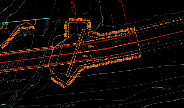
Figure 1 Example erosion control detail with DDAs delineated.
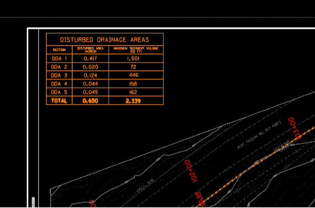
Figure 2 Example DDA table with areas and sediment volume requirements.
If construction activities are covered by KYR10 general permit criteria, a Notice of Intent (NOI) is required before work can be authorized to begin. Once the construction contract has been awarded, and at least 10 days before construction beginssubmits the NOI to KDOW. This may be the DEC, DEA staff, KYTC construction staff, contractor, or other KYTC representative who can access the authorization numbers associated with project submittals that have been made through KDOW. The eNOI is filed using the Energy and Environment Cabinet’s One-Stop System, which is an online resource with links for electronic permit applications and other business tools.
An operator must obtain the Notice of Coverage (NOC) issued by KDOW before they engage in activities which disturb the ground, even if there is a delay once the eNOI is filed. The NOC authorizes earth-disturbing activities under the terms of the KPDES permit.
BMP and SPCC Plans. KYR10 requires adherence to erosion control BMPs found in KYTC’s current Standard Specifications. Contract documents (e.g., the proposal) include additional stipulations for complying with erosion control BMPs. When KDOW approves a KPDES stormwater permit, a copy of the permit and any accompanying documents are included in project bid documents. Techniques for mitigating impacts authorized by individual KPDES permits are addressed with what are called enhanced erosion control measures. These measures may be incorporated into the project during construction and/or permanently constructed.
The contractor prepares an initial BMP Plan using the aforementioned template that is included in the proposal. This BMP plan will also include provisions for pollutant containment (SPCC Plan). The BMP plan addresses all facets of the project, including sediment control in waste areas, borrow pits, and haul roads. Site-specific details shown on the original plans are included in the BMP Plan, or a detailed analysis is done to demonstrate a better result may be achieved. This plan, in its initial form, is signed at the preconstruction conference before work commences.
The SE enforces requirements set forth in Section 212 (Erosion Control) and Section 213 (Water Pollution Control) of the Standard Specifications. Enforcement of provisions in these must be consistent with how other Specifications and contract documents are enforced. Liquidated damages can be assessed when the contractor is noncompliant with erosion control requirements.
At the preconstruction conference, general and project-specific requirements are discussed, and responsible parties for the contractor and KYTC identified. Applicable permits and conditions are reviewed. Emergency procedures and contacts are approved and documented.
KYTC includes temporary erosion control information included in the bid package to help proposers prepare cost estimates, however, it is only a starting point. The sequence of operations and seasonality of the project may prompt the lead contractor and KYTC construction staff to amend the initial plan for temporary measures. Permanent measures are not modified without consulting DEA staff.
Regulatory agencies may ask to inspect project records if they make a site visit. Copies of the following project records should be kept on site:
- USACE and KDOW permits,
- NOI,
- BMP Plan,
- Subcontractor certifications,
- Erosion control inspection reports,
- USACE 404 permits, and
- Project-specific records.
Inspector Qualification Erosion control measures are reviewed by staff who have successfully completed KYTC’s KEPSC Inspector Qualification Training and Testing Course. Minimum inspection frequency is dictated by rain events and the evolution of site conditions (i.e., progression of the work). Inspections for active sitework are performed 1) every seven (7) days, and 2) within 24 hours of a rainfall of 0.5 inches or greater. Inspections continue monthly for inactive sitework until formal project acceptance. Inspection forms (TC 63-61 or TC63-61A) include the inspector’s name and qualifications, inspection date, major observations related BMP Plan implementation, and corrective actions previously taken.
Depending on how the KPDES permit was obtained, either KYTC staff or contracted inspection services may be responsible for overseeing the contractor’s compliance with erosion control measures, the BMP plan and SPCC plan. Throughout the construction project, erosion and sediment control measures and spill prevention measures undergo regular inspections. Inspection records are kept onsite.
Planned inspections focus on:
- BMP Plan. Control measures listed in the BMP Plan are inspected for correct operation and sufficiency. The BMP Plan and site map are referenced and should be current. The BMP Plan includes a seeding plan and a SPCC Plan. The BMP Plan is coordinated with the construction phasing for the project. The BMP Plan minimizes soil erosion of exposed slopes and maximizes sediment retention on-site
- Construction entrances. Construction entrances are checked for evidence of offsite sediment tracking.
- Disturbed areas and their discharge locations. The effectiveness of velocity dissipation devices or sediment barriers are inspected at locations where ditches or sheet runoff leaves the site to ensure they are preventing significant impacts to receiving waters. Runoff from disturbed areas is treated by erosion controls, sediment controls, or a combination of these before entering the drainage system. Disturbed areas with excessive erosion that need additional controls are noted. Control measures are inspected to evaluate whether they have been adequately installed and function effectively. Their location is recorded on the inspection form. Inspectors must note controls that need maintenance. The contractor is responsible for installing (and paying for) temporary erosion control work that is necessary due to negligence (e.g., failure to install permanent seeding during favorable conditions or other permanent controls as directed). The contractor receives copy of inspection reports which stipulate remedial action from the inspector.
- Perimeter controls. They are inspected for pollutants entering the drainage system or moving offsite.
- Material storage. Material storage areas exposed to precipitation are inspected for pollutant releases. The inspector notes areas where potential pollutants are exposed or areas where material must be covered or contained. Check for pollutants stored near a waterway where no means exist to prevent material from entering the stream were an accidental spill to occur. Reference the BMP Plan, groundwater protection plan, and Oil Pollution SPCC plans for specific requirements.
- Temporarily or permanently stabilized areas. These are inspected at least once a month to verify that erosion controls remain viable. Inspections should also verify that construction activity is not occurring in these areas.
Remedial Action Required. When inspectors find that erosion control measures require remedial action, they document this within the inspection report as well as the Daily Work Report. A copy of the inspection report serves as the Engineer’s written notification to the contractor. If there is a failure to satisfactorily install temporary or permanent erosion controls, the SE may withhold a contractor’s pay and suspend operations. Section 213 of the Standard Specifications establishes authority for this action and for assessment of liquidated damages.
Site Visits from Jurisdictional Agencies. When the representative of a jurisdictional agency (e.g., KDOW, USACE) conducts a site visit, KYTC must accommodate their requests in every way practical. If notified in advance, DEA may accompany KDOW personnel on site visits. Due to their regular communication with each regulatory agency, DEA staff are best able to help resolve a question when one arises.
Should a local office (District or Section) receive a formal letter Notice of Violation (NOV), both Central Office DEA and Construction are immediately notified. Levels of concern correspond to variations in NOV letters. The first and lowest level of concern is a warning. The next level is response required (DEA staff in Central Office help draft KYTC’s formal response). If an enforcement conference is required (the most severe NOV letter), and if the enforcement conference does not bring about a resolution, KYTC legal staff will attend to the issue in coordination with DEA staff.
It’s more likely for an agency representative to look over the project documentation than to issue a formal NOV. Central Office DEA facilitates these requests. By sharing its project records, KYTC demonstrates compliance with the KPDES stormwater permit and other permit requirements.
Temporary Erosion Control Measures. These are used until a satisfactory permanent stand of vegetation exists, as defined within Section 212 of the Specifications. The following temporary installations, in combination and individually, can be used to protect disturbed areas on the project site (including contractor haul roads, borrow pits, and waste areas):
- Brush Barriers – linear sediment filter constructed of brush cleared from the project site. Brush barriers are placed along contour lines and are intended to intercept overland sheet flow.
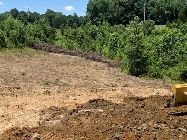
Brush Barrier
- Silt Trap Type A – excavated basins in natural or constructed channels and constructed berms built to pond water so that the suspended silt load will be deposited. These are typically used in roadway ditches, median ditches, surface ditches, and special ditches. Silt Traps Type A are best applied in locations where small and infrequent runoffs are expected. They may be placed in a series to achieve a necessary volume
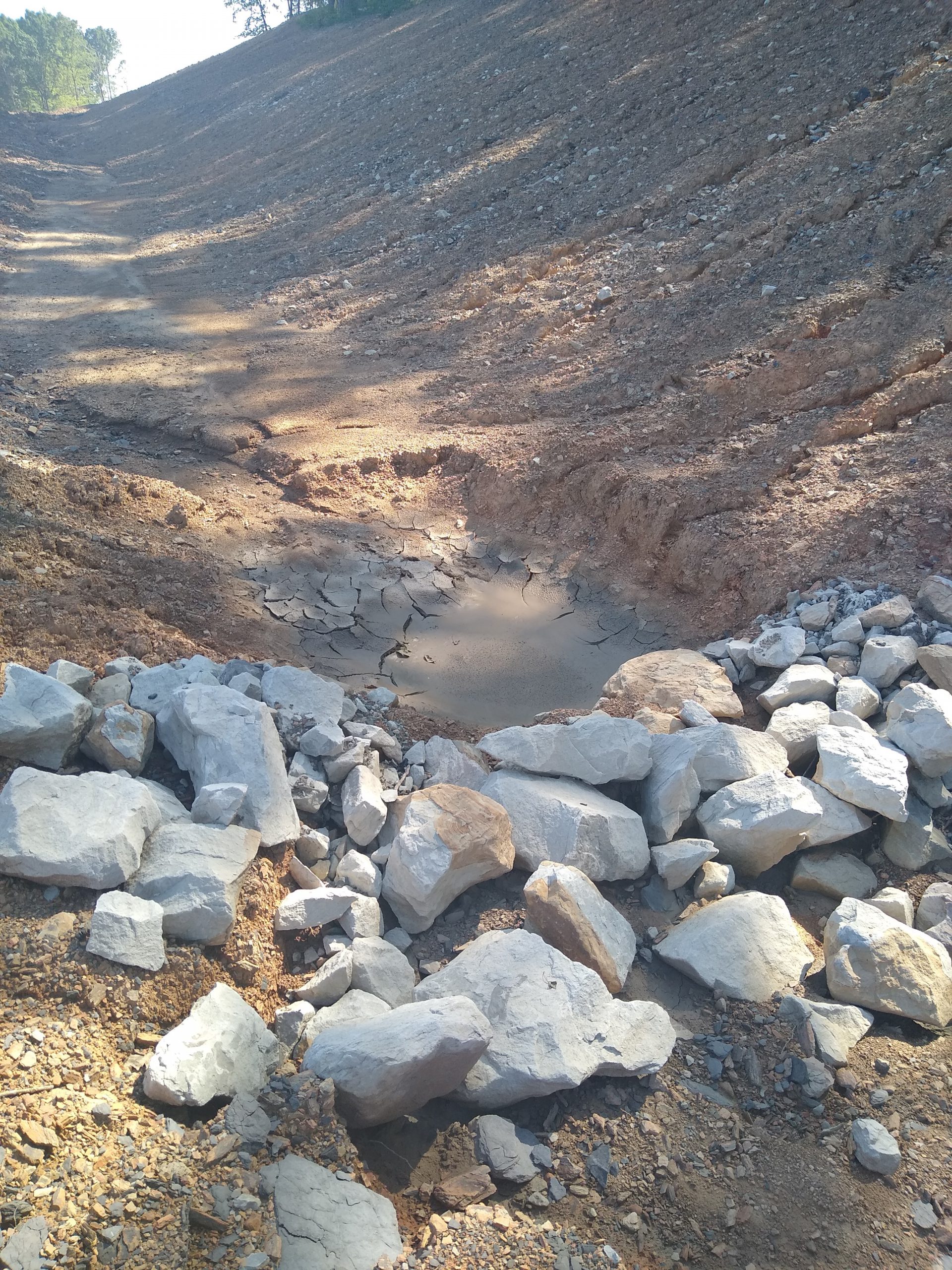
Silt Trap Type A
- Silt Trap Type B – one or more small berms placed in a natural drain, an excavated channel, or a ditch. They may be placed in a series and are constructed of #2 stone or shot rock of similar size and filtered through a geotextile fabric that is covered by smaller stone. A depression is made in the middle of the berm to ensure flow doesn’t divert around the structure.
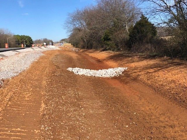
Silt Trap Type B
- Silt Trap Type C – a series of porous fabric bags filled with crushed aggregate placed at the inlet of drainage structures to minimize the siltation of those structures.
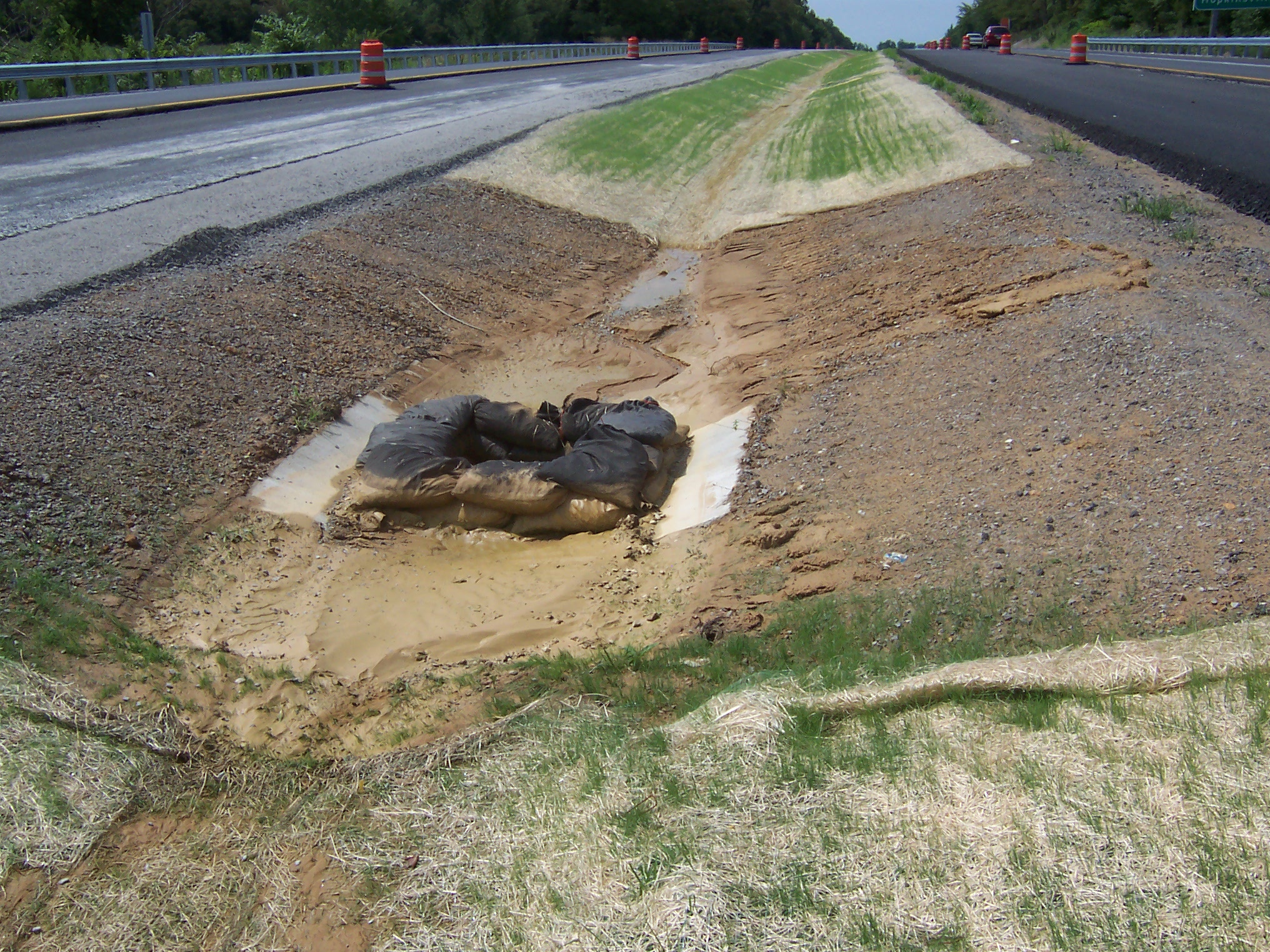
Silt Trap Type C
- Sedimentation Basins – used and designed to protect specific sites where over 10 acres of disturbed ground. A sedimentation basin is appropriate at locations where it is necessary to provide a larger storage volume or to provide more effective sediment control to achieve a specific purpose such as protection of a specific resource. The sedimentation basin is similar to a Silt Trap Type A, but it has more capacity and a higher dam. Sedimentation basins are site-specific designs that meet drainage analysis required by established guidance, including but not limited to the KYTC Drainage Design Manual and the Highway Design Manual. Existing ponds within project limits may be used as temporary sediment basins.
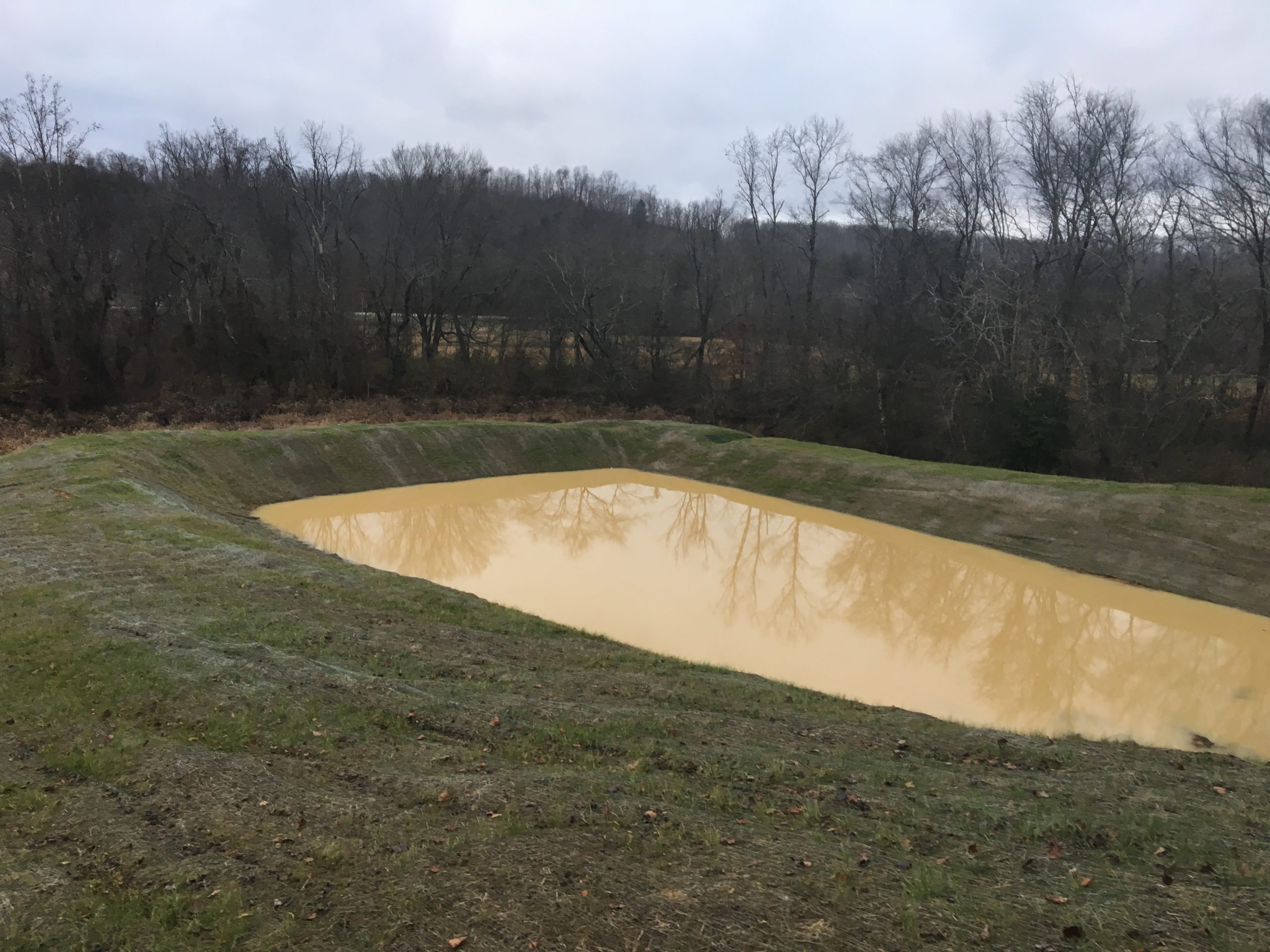
Sedimentation Basin
- Silt Fence – sediment barrier entrenched into the soil and attached to supporting posts. Silt fence is used to intercept overland sheet flow. A single row or multiple rows can be used if necessary to minimize erosion for long slopes.
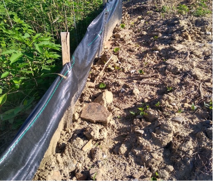
Silt Fence
- Temporary Mulch – Mulch is used to temporarily stabilize seeded or unseeded bare soil areas, to protect the soil surface from raindrop impact, to increase infiltration, to conserve moisture, to prevent soil compaction or crusting, and to decrease runoff.
- Temporary Seeding and Protection – Temporary seeding uses rapidly growing grass to stabilize bare soil areas that will be disturbed again before construction is complete.
- Temporary Ditches – divert runoff to silt basins or traps. Permanent ditches constructed early in the construction phase may be used to effectively trap sediment.
Temporary silt traps, silt fence, and sedimentation basins are cleaned before their trapped sediment load inhibits their effectiveness. Bid items are included in construction contracts to provide for this work. Brush barriers, silt traps, silt fence, and sedimentation basins are removed when permanent erosion and sediment control measures have been successfully established.
Permanent erosion control measures are left in place after the construction is complete and can provide long term benefits to erosion prevention and water quality after the project is constructed.
Permanent Seeding and Protection Section 212 of the Standard Specifications discusses seed mixtures, rates, materials, and procedures required for permanent seeding operations.
Sodding Sections 212 and 827 of the Standard Specifications address sodding requirements. All sod is inspected at the source and is subject to inspection on the project site. Any sod that has browned out or contains weeds is rejected or culled. Sod is guaranteed in accordance with Section 212 of the Standard Specifications.
Erosion Control Blanket Section 212 of the Standard Specifications discusses procedures and requirements related to erosion control blankets. Erosion control blankets are commonly used on slopes and in channels and ditches.
Permanent Turf Reinforcement Mat The Special Note 11F on the Division of Construction’s webpage discusses permanent turf reinforcement matting requirements. Installation details are offered in KYTC Sepia drawings.
Rock gabion mattresses provide protection and stability through a wide range of slopes and discharges. The gabion mattress permits a smaller size rock than would be recommended for a riprap-lined channel. This is possible because the rock is bound by the wire mesh, which provides stability such that the gabion mattress tends to act as a unit.
Top Dressing Top dressing is an application of fertilizer (e.g., agricultural limestone) — at a predetermined strength and rate — on specified seeded and sodded areas that have an existing stand of satisfactory vegetation. Depending on the situation, it will not normally be applied until after project until it is complete. A decision about applying top dressing is made at the same time as the “Acceptance of Seeding” inspection.
Acceptance of Seeding (and Plantings) The contractor (KPDES operator) cares for and maintains all erosion control in a satisfactory condition throughout the life of the contract. The Acceptance of Seeding inspection is performed jointly with the final Inspection on projects with small areas of disturbance (e.g., those covered under a Nationwide Permit 14).
For all other projects, the Division of Construction liaison determines whether the permanent erosion control complies with Section 212 the Standard Specifications. Site inspection occurs between 3 and 6 months after a project is complete except in cases where a delay is warranted because conditions prevent a clear determination of the vitality of the vegetation.
When the Acceptance of Seeding inspection deems corrective work necessary for the project seeding to achieve a satisfactory condition, procedures and payment follow Section 212 of the Standard Specifications. Section 108.09 of the Standard Specifications includes a timeframe for completing corrective work.
After a project has been formally accepted, a Notice of Termination (NOT) . The NOT ends coverage under the KPDES permit because construction is complete and permanent stabilization measures appear successful.
Long Term Maintenance of Permanent Erosion and Sediment Control Measures Permanent erosion and sediment control measures require periodic maintenance after construction complete. These duties are the responsibility of the Division of Maintenance and include periodic inspection and may involve correct measures such as reestablishment of vegetation and cleaning of drainage ditches and structures.
- Standard Drawings
- RDD-030-08 Channel Lining Class IA (Mattress Units)
- RDD-040-05 Channel Lining Class II and Class III
- RDI-040-01 Erosion Control Blanket Slope Installation
- RDI-041-01 Erosion Control Blanket Channel Installation
- RDX-210-03 Temporary Silt Fence
- RDX-215-01 Temporary Silt Fence with Woven Wire Fence Fabric
- RDX-220-05 Silt Trap Type A
- RDX-225-01 Silt Trap Type B
- RDX-230-01 Silt Trap Type C
- Sepia Turf Reinforcement Mat Channel Installation
- Sepia Turf Reinforcement Mat Slope Installation
- KY Standard Specifications for Roads and Bridges
- 211 Final Dressing
- 212 Erosion Control
- 213 Water Pollution Control
- KYTC Highway Design Guidance Manual HD-204-14
- KYTC Drainage Design Guidance Manual (Memo 3-05 references Chapter 10 – not published, not referenced on KYTC website)
- KYTC Construction Guidance Manual CST-400
- KYTC Environmental Analysis Guidance Manual EA-1108
- KYTC List of Approved Materials
- KYTC BMP Manual https://transportation.ky.gov/EnvironmentalAnalysis/Environmental%20Resources/KY%20BMP%20Manual%20Section%201.pdf#search=Nationwide%20permit (referenced by DEA webpages)
- KYTC Construction Memos: (CM year-memo number)
- CM 19-05 Bridging Kentucky projects – Environmental Impacts
- CM 17-02 eNOI System for KYTC Const Stormwater Permits & Consistency in Proposal Content
- CM 13-01 Temporary Construction Entrances and Erosion Control Blanket
- CM 11-04 KPDES Permits Obtained by the Contractor
- CM 11-01 KEPSC-RI
- CM 09-08 NOI eForm Policy
- CM 07-03 KPDES
- CM 06-02 KPDES BMP Inspection & Maintenance (DM 02-06)
- T2 KEPSC Roadway Inspector Training Coursebook
Kentucky Energy and Environment Cabinet http://water.ky.gov/waterquality/pages/integratedreport.aspx
KYTC and Division of Water documents and forms
Clean Water Act https://www.epa.gov/laws-regulations/summary-clean-water-act#:~:text=The%20Clean%20Water%20Act%20(CWA,quality%20standards%20for%20surface%20waters
Executive Order 13778, April 20, 2020 instructs EPA and USACE to revise the regulatory definition of WOTUS from the June 29, 2015 rule for Fed. Reg. 37054. https://www.federalregister.gov/documents/2015/06/29/2015-13435/clean-water-rule-definition-of-waters-of-the-united-states
