Search for articles or browse our knowledge portal by topic.
Kentucky Geohazards and Their Impacts to Highways and Bridges
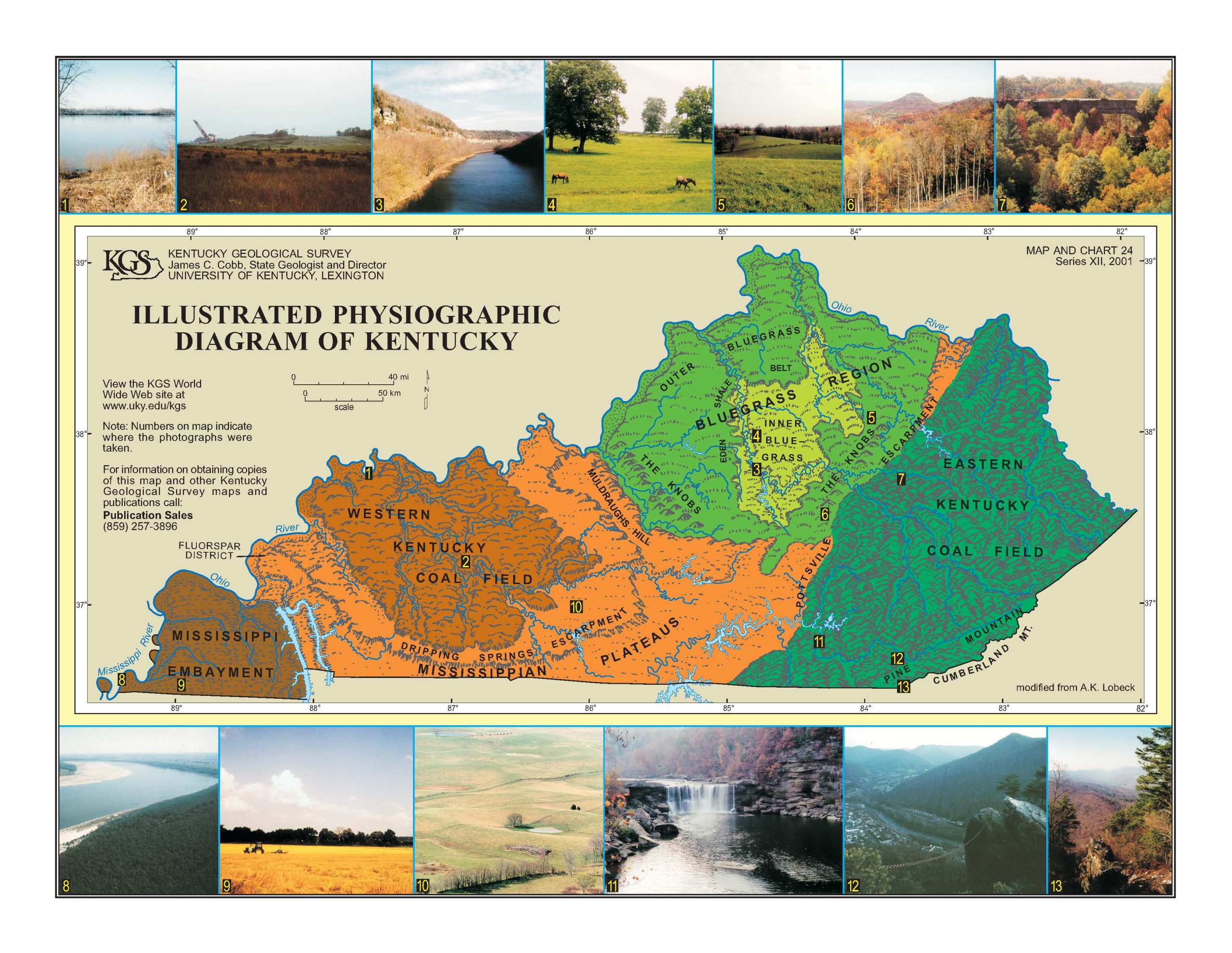
Kentucky’s terrain varies greatly from the relatively flat-lying areas of the Jackson Purchase in Western Kentucky to the mountainous terrain of the Eastern Kentucky Coalfields. Over time, tectonic and weathering forces have lifted, bent, and eroded underlying bedrock to create the landforms we see today. Physiography studies how these landforms were created. Figure 1 shows the six physiographic regions of Kentucky. Each region has distinct characteristics that impact their ecological and economic identities. The Kentucky Geological Survey (KGS) provides extensive information on these physiographic regions.
Figure 1. Physiographic Regions of Kentucky. Image courtesy of KGS (mc24_12).
The six physiographic regions are the:
- Jackson Purchase or Mississippi Embayment
- Pennyroyal or Mississippian Plateau
- Western Kentucky Coal Field
- Knobs
- Bluegrass
- Eastern Kentucky Coal Field
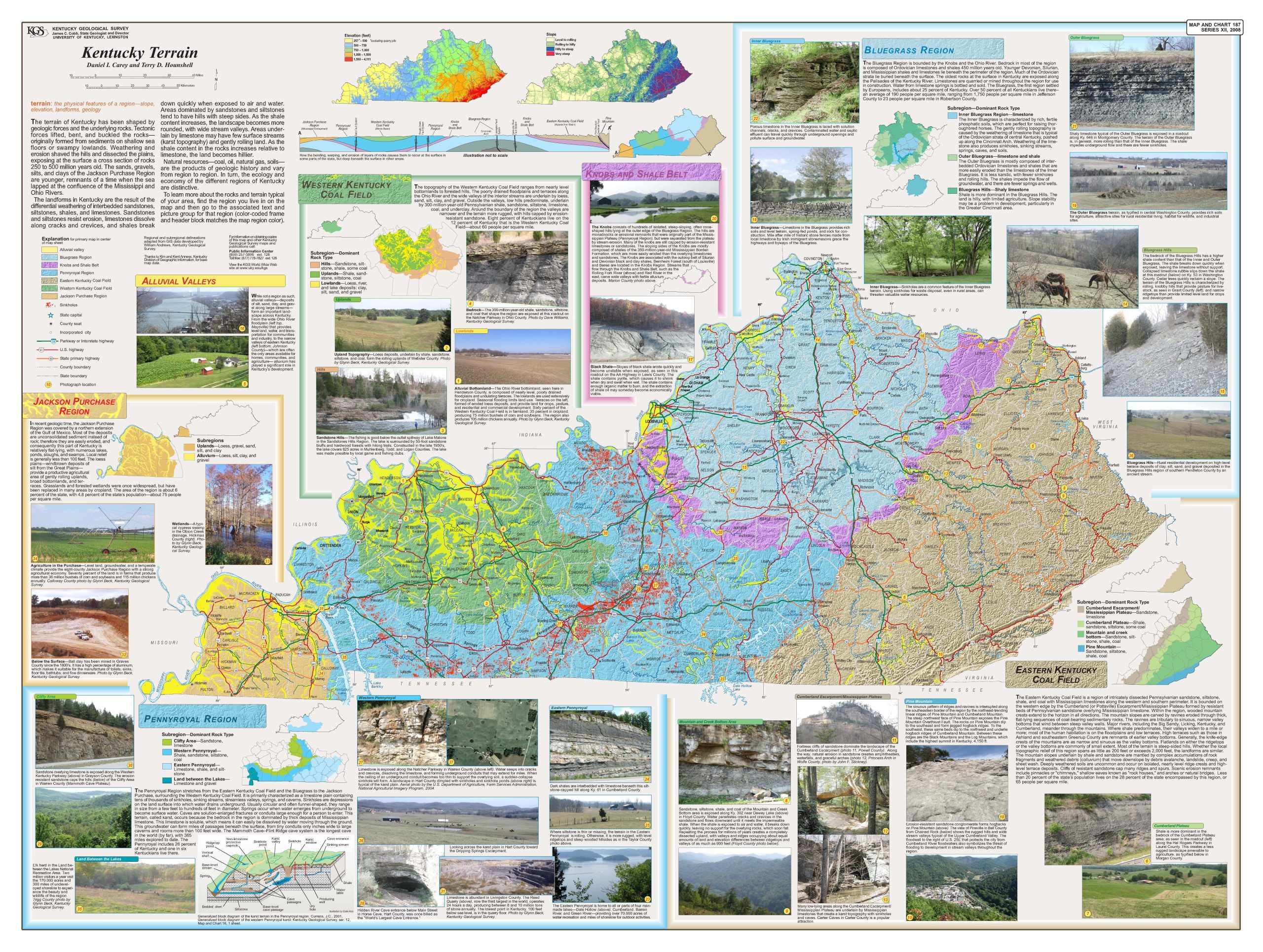
Figure 2 summarizes the characteristics of each region, including their geology and terrain. The characteristics of each region create geohazards that impact the planning, design, construction, and operation of highways and bridges as well as other types of infrastructure.
Figure 2. Kentucky Terrain (Carey and Hounshell, 2008)
Terms
The full definitions for terms included in this article (listed below) can be found in the HKP Glossary.
- Black Shales
- Dipping bedrock
- Dolomite
- Karst
- Landslides
- Limestone
- Physiographic Regions
- Porters Creek Clay
- Pennsylvanian-age shales
- Rockfalls
- Sandstones
- Siltstones
- Shale
- Scour
2.1 Jackson Purchase
The Jackson Purchase region, also known as the Mississippi Embayment, is located in far Western Kentucky and is generally bounded by the Mississippi River to the west, the Ohio River to the North, and Kentucky Lake to the east. The Gulf of Mexico extended over this area during the late Cretaceous period, leaving deep deposits of unconsolidated sediment. Bedrock is often several hundred feet below the ground surface. Windblown silts (called loess) from the Great Plains cover the area, providing fertile cropland. This region has some of the lowest elevations above sea level in Kentucky, resulting in numerous lakes, ponds, and swamps.
Geohazards associated with this region include:
- Earthquakes — The region is also underlain by the New Madrid Fault Zone, which is the most active fault zone in the United States east of the Rocky Mountains and the location of the strongest recorded earthquakes in U.S. history.
- Erosion, scour, and stream migration — Friction piles are commonly used in this region to support bridges because of the deep soil deposits and depth to bedrock. Scour and stream migration removes soil that supports these piles, can impact other drainage structures (e.g., culverts, pipes), and undercut bridge approach embankments.
- Landslides — Erosion and stream migration results in landslides along the bluffs of the Mississippi River.
- Mining — Sands, gravel, and ceramic clays have been mined in this region.
- Porters Creek Clay — The Porters Creek Clay formation includes clays that are sensitive to moisture and may shrink or swell depending on changes in moisture. These clays have been mined for their adsorptive ability (e.g. kitty litter, industrial adsorbents). Porters Creek Clay also creates design and constructability concerns for structures supported on piles.
2.2 Pennyroyal
The Pennyroyal region, also known as the Mississippian Plateau, is underlain by Mississippian-age limestones. These limestones are water soluble, which means they can dissolve due to water flowing through the ground. This in turn creates caves, sinkholes, closed depressions, sinking and underground streams, and springs. This terrain is commonly referred to as karst. The term karst plain is used to describe the undulating and dimpled ground surface associated with karst features. Mammoth Cave is in this region. The Dripping Springs and Muldraugh Hills Escarpments are a ring of hills that pass through the region and are created by more erosion-resistant limestones and sandstones capping erosion-prone shales and limestones.
Geohazards associated with this region include:
- Earthquakes — Projects in the western and southwestern portions of the region may need to consider earthquake effects from the New Madrid and Wabash Valley Fault Zones.
- Karst — Collapse of caves and sinkholes is a major concern. Because of the underground streams and lack of surface drainage features, finding ways of dealing with surface drainage from highway facilities can be challenging. Although bedrock is relatively shallow, undulating bedrock surfaces due to karst features can make it difficult to find suitable bearing for structures as well as establish stable rock cut slopes.
- Black shales — Black shales can outcrop in the southeastern portion of the region where the Pennyroyal borders the Knobs and the Eastern Kentucky Coal Regions. Where present, these shales produce acid runoff and require special construction procedures for fills, cuts, and structure foundations.
- Mining — Mineral mining of limestone occurs in this region. Faulting of bedrock in Livingston and portions of Crittenden counties led to deposition of fluorite, which was heavily mined during World War II and the mid-1960s.
- Oil and Natural Gas Wells — Natural gas production can occur around the southern and eastern boundaries of the Pennyroyal with the Western Kentucky Coal Field. Oil production can occur in the southeastern area of the region.
2.3 Western Kentucky Coalfield
The Western Kentucky Coal Field region is underlain by Pennsylvanian-age shales, limestones, siltstones, sandstones, coal, and underclays. This region is the southern portion of a larger geologic feature known as the Illinois Basin, which includes the coal fields of Illinois and Indiana. Alluvial floodplains of the Ohio River form the northern border of the region. Terrain varies from nearly level bottomlands along rivers and streams, to gently rolling hills, to rugged hills capped by erosion-resistant sandstone along the western, southern, and eastern borders of the region.
Geohazards associated with this region include:
- Earthquakes — Projects in the western two-thirds of the region may need to consider earthquake effects from the Wabash Valley and New Madrid Fault zones.
- Landslides and rockfalls — Landslides are possible due to unstable shales, rugged terrain, and mining activities.
- Mining — Surface and underground mining can result in subsidence, landslides, and deep deposits of strip mine spoil.
- Oil and Natural Gas Wells — Oil and natural gas wells are found throughout the region.
- Flooding, Scour and Stream Migration — Alluvial bottomlands along streams and rivers are subject to flooding, scour, and channel migration. Erosion from these processes can undermine roadways and structure foundations.
2.4 The Knobs
The Knobs region, also known as the Shale Belt, borders the Bluegrass region and consists of numerous cone-shaped hills with steep slopes. These hills are capped by erosion-resistant limestone or sandstone underlain by more erodible Mississippian-age shales. The Knobs are also associated with outcrops of Devonian-age black shales and the erodible clay shales of the Borden Formation. Streams that flow through this region (e.g., Rolling Fork and Red Rivers), have carved wide alluvial floodplains.
Geohazards associated with the region include:
- Landslides and Rockfalls — Because Mississippian-age clay shales are easily eroded, rock cut slopes in these shales can rapidly deteriorate. Embankments built out of or on these shales can be unstable and result in landslide movements.
- Black shales — Devonian-age black shales contain pyrite, which can shrink when dry and swell when wet. This can create problems for the foundations of structures built on or out of these shales. These shales also produce acid runoff and require special construction procedures for fills, cuts, and structure foundations.
- Flooding, Scour, and Stream Migration — The wide floodplains are often subject to flooding. Alluvial deposits are easily eroded and can scour bridge foundations. Stream channels can easily migrate due to the erodibility of alluvial deposits and undercut bridge approach embankments or nearby roadways.
- Earthquakes — Projects in the northeastern portion of the Knobs (Lewis, Rowan, Bath, and Menifee Counties) may need to consider the effects of earthquakes.
2.5 Bluegrass
The Bluegrass region lies in the central portion of the state and is bounded by the Knobs region and the Ohio River to the north. Bedrock in this region generally consists of limestones and interbedded limestones and shales that were pushed up along the crest of the Cincinnati Arch. Three subregions, each with different dominant rock types, further define this region — Inner Bluegrass, Outer Bluegrass, and Bluegrass Hills. The Inner Bluegrass subregion is defined by karstic limestones that produce phosphatic soils perfect for raising thoroughbred horses and springs that provide water for bourbon production. The Outer Bluegrass subregion has more rolling terrain and is defined by interbedded limestones and shales that are less prone to karst. The Bluegrass Hills subregion bedrock contains more shale and thus is hillier and prone to landslide problems. The Kentucky River cuts through the region creating the Palisades where the oldest bedrock in Kentucky is found.
Geohazards associated with this region include:
- Karst — The potential for karst features is high in the Inner Bluegrass, and to a lesser extent in the Outer Bluegrass. Spills of toxic materials can enter the groundwater through sinkholes, potentially polluting springs.
- Landslides — The potential for landslides exists in the Bluegrass Hills, and to a lesser extent in the Outer Bluegrass, due to the clay shales and rolling topography.
- Earthquakes — Projects in the northeastern portion of the region may need to consider the effects of earthquakes.
- Mining — Limestone is quarried for construction materials.
2.6 Eastern Kentucky Coal Field
The Eastern Kentucky Coal Field is bounded on the western edge by the Knobs and Pennyroyal regions. This western edge is called the Pottsville or Cumberland Escarpment and is composed of resistant sandstones and conglomerates. The weathering of these sandstones results in well-known features such as natural bridges, arches, gorges, cliffs, and waterfalls (e.g., Natural Bridge, Red River Gorge, Cumberland Falls). In low lying areas of the Escarpment, Mississippian-age limestones outcrop that create karst topography (e.g., Carter Caves). Further east, sandstones, siltstones, shales, and coal become more prominent. The weathering of these rocks resulted in winding, narrow valleys with steep-sided hills. The Pine Mountain Thrust Fault pushed resistant sandstones up and over a portion of southeast Kentucky creating a 125-mile-long mountain ridge. The area between Pine Mountain and Cumberland Mountain contains the highest summits in Kentucky (e.g., Black Mountain).
Geohazards associated with this region include:
- Mining — Coal is the predominant mined mineral in the Eastern Kentucky Coal Fields. Limestone quarries also exist along the border with the Knobs and Pennyroyal Regions. In the northern part of the region, there is some mining for clay. The stability of rock cuts can be impacted when encountering mine openings, and abandoned mines filled with water can be subject to blowouts. Strip mine spoil and hollow fills can cause difficulty in the construction of roadways, soil cut slopes, and structure foundations.
- Oil and Natural Gas Wells — Natural gas, and to a lesser extent oil, is recovered from the region.
- Landslides and Rockfalls — Landslides and rockfalls are common due to the weathering of clay shales and rugged, steep terrain. Infrastructure projects may also encounter unstable colluvium and talus (soil and rock materials transported downhill by gravity) that are remnants of past landslide and rockfall movements. Landslides are also possible in the remnants of strip mines and hollow fills.
- Faults and Dipping Bedrock — The Pine Mountain Overthrust Fault and related dipping bedrock can present challenges for highway infrastructure. Because the bedrock layers are not horizontal, roadway alignments and grades can encounter very different geology over very short distances. Thus, roadway line and grade construction around this fault, and in particular rock slopes, is challenging. Tilted bedrock also increases the possibility of large block movements or slides in rock cuts.
- Karst — Karst features are possible in the limestone areas along the border with the Knobs and Pennyroyal Regions. This potential extends from the Carter Caves area in the northern part of the region to Wayne County and the Tennessee border.
- Flooding, Scour, and Stream Migration — Because of the steep hillsides and narrow valleys, runoff and flooding can occur quickly. Although there are typically only minor amounts of alluvial soils in valleys, these soils can be quickly scoured and eroded, exposing bridge foundations, overtopping embankments, and undermining nearby roadways.
- Earthquakes — There is potential for earthquake impacts in the northern portion of the region. Earthquake impacts are also possible in the southern part of the region due to the Eastern Tennessee and Giles County Virginia Seismic zones.
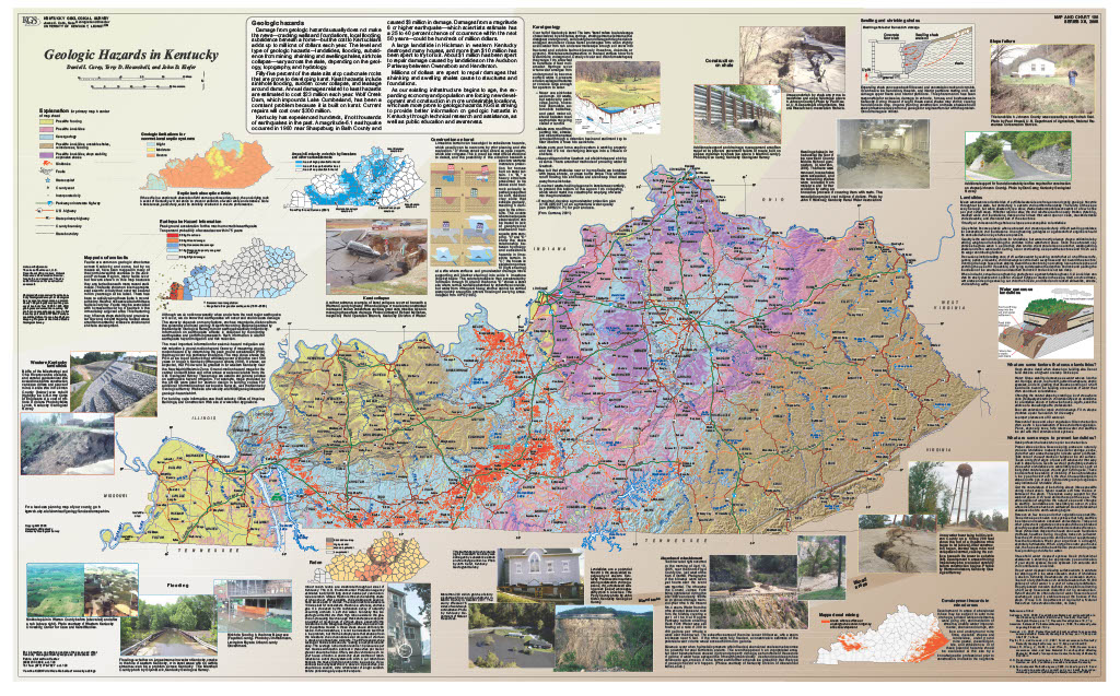
As noted, the physiography and geology of Kentucky create the potential for geohazards that impact the design, construction, and maintenance of almost all types of infrastructure, including highways and bridges. Carey, et. al. (2008), developed a map (Figure 3) that illustrates locations of geohazards across Kentucky and their impact on infrastructure.
Figure 3. Geologic Hazards in Kentucky
Blandford, et. al. (2018) identified potential vulnerabilities to extreme weather events and natural hazards for routes on the National Highway System in all 12 KYTC highway districts. They evaluated the risks presented to highways, bridges, and culverts by geohazards such as earthquakes, flooding, landslides, and sinkholes.
3.1 Karst
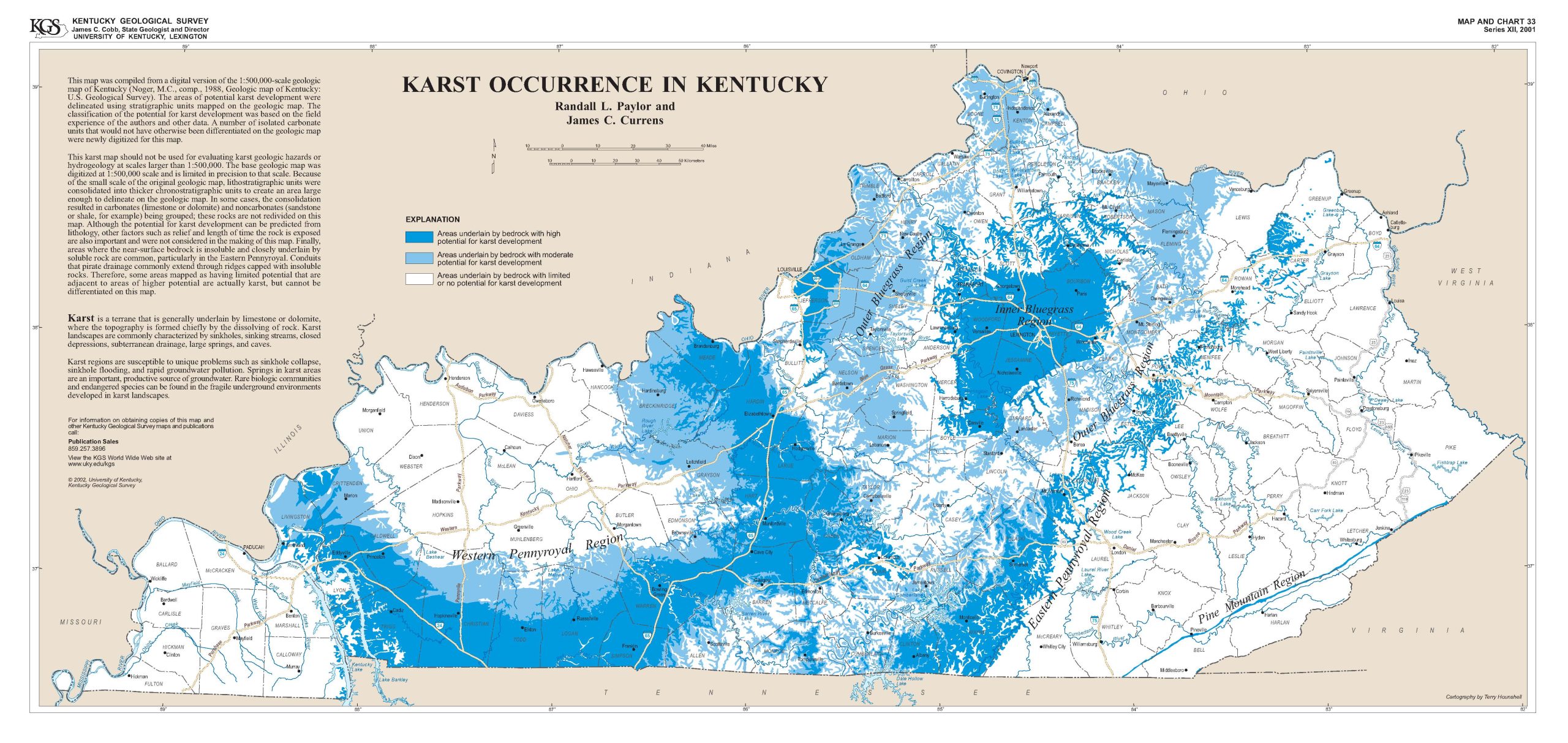
Terrain that consists of sinkholes, caves, sinking streams, and springs is typically referred to as karst. Karst is formed when weak acids found in precipitation and groundwater dissolve soluble limestone bedrock. The undulating and dimpled ground surface associated with karst features is commonly referred to as a karst plain. Kentucky is famous for its karst features (Mammoth Cave), and a little over 50 percent of Kentucky has bedrock that can develop karst features. KGS has information on karst and its related hazards, including maps (Figure 4) that show the potential for karst occurrence across the state.
Figure 4. Karst Occurrence in Kentucky (Paylor and Currens, 2001)
Common hazards associated with karst that impact highways and bridges are cover collapse, flooding, and groundwater contamination. While avoiding karst areas is the only way to prevent karst-related hazards, avoidance is impractical given the potential for karst occurrence in Kentucky. Even with a well-planned and executed subsurface investigation, it is impossible to identify every karst feature in a project area. Often the presence of a karst feature is not identified until construction, and sometimes they are not found until years after construction has been completed.
Cover collapses occur when the cave roof or the soil arch over a sinkhole falls into the void beneath them. They can result from material being unable to support the weight above it or by erosion of soil material into the void by surface water or groundwater. Cover collapses can be gradual or sudden and range in size from small to very large (e.g., 2014 Corvette Museum sinkhole). Cover collapses can impact structure foundations, roadways, and surface drainage. KYTC has methods to treat sinkholes to prevent collapse while allowing for subsurface and/or surface drainage to continue. These involve cleaning the sinkhole and refilling it with graded stone. The sinkhole can then be capped if necessary to provide for construction of embankments or roadways.
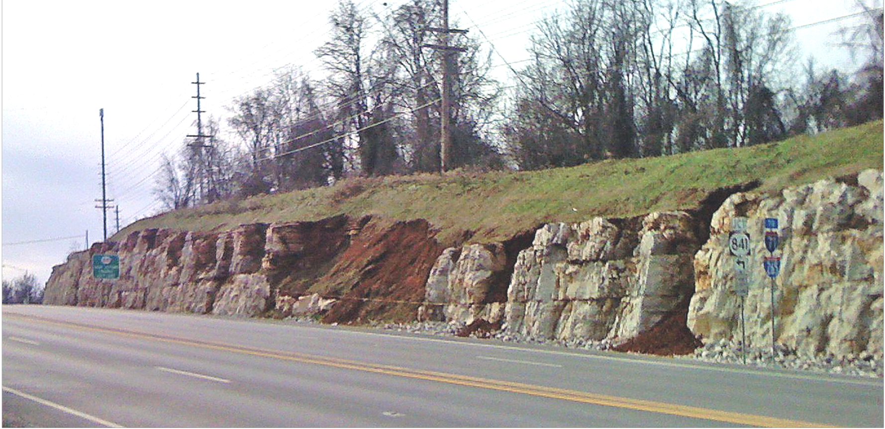
The undulating surface and the presence of voids within bedrock in karst areas presents problems for the construction of bridge or other structure foundations. Uneven bedrock surfaces, enlarged fractures, and voids due to dissolving of bedrock makes it difficult to construct spread footings, drive piles, or construct deep foundations such as drilled shafts to support bridges. Often deeper excavations, additional concrete, additional and longer piling, and steel casings are needed to extend foundations through karst features into competent bedrock. The irregular bedrock surfaces of karst also present issues with the construction of rock cuts (Figure 5). Figure 5 illustrates the issues with rock cuts in karst; it is also useful for visualizing problems that would arise with construction of a structure foundation.
Figure 5. Solution features in a cut slope along US 42 in Jefferson County, Kentucky
Accommodating surface and subsurface drainage can also be challenging in karst. Sinkholes, sinking streams, and caves are natural ways of dealing with precipitation runoff. Often these features cannot handle water inflows, which results in flooding, especially if development in the area increases runoff volumes. Special designs may be needed to effectively handle runoff from roadways and bridges entering sinkholes. Springs may not flow during dry periods and thus may not be identified during roadway planning, design, and even construction phases. If not properly addressed with spring boxes or outlet pipes, springs can produce flooding or landslides when activated during wet periods.
Runoff from roadways and bridges may need to be treated in some way to prevent oils, grease, and other contaminants from entering karst features. Spills of toxic materials can enter groundwater through sinkholes, potentially damaging sensitive cave ecosystems and polluting springs.
3.2 Landslides and Rockfalls
Landslides typically occur in steeper terrain with clayey or shaley soils; however, slides can be triggered by other factors such as precipitation, flooding, erosion, soil conditions, steepness of slope, construction procedures, and human activity. Please refer to the Highway Knowledge Portal article on Landslides for more information on their causes, signs of instability, and repair methods. KGS also provides information about landslide hazards.
Rockfalls also typically occur in areas with steeper terrain with non-durable shale layers. They can be triggered by precipitation, joints, dipping bedding planes, faults, construction procedures, and human activities. Please refer to the Highway Knowledge Portal article on Rock Slopes and Rockfalls for more information on their causes, signs of instability, and repair methods.
3.3 Earthquakes
Several seismic zones may produce earthquakes that affect Kentucky. The most notable is the New Madrid Seismic Zone, which impacts much of Western Kentucky. Other seismic zones that impact Kentucky include the Wabash Valley, Eastern Tennessee, and Giles County (Virginia). Although a seismic zone is not associated with it, Northeastern Kentucky has experienced earthquakes that caused damage.
The ground motion, or shaking, from an earthquake typically causes the most damage to the built environment, but local geology and soil conditions also influence the potential damage. Soft soil above the bedrock can amplify ground movement, creating more intense shaking. Soft, water-saturated sandy soils can undergo liquefaction during strong ground movements because shaking increases groundwater pressure. Liquified soils cannot support structure loads, and the soil can flow creating lateral spreading of the ground. Structures can settle, buried structures can float to the surface, and retaining walls can be subjected to increased lateral pressures. Often, liquified soil will force open ground cracks to escape and relieve increased groundwater pressure, creating sandblows or sand boils. Areas along river valleys with their extensive alluvial deposits (e.g., Mississippi and Ohio River valleys), are prone to liquefaction. Earthquakes can cause embankment failures, landslides, rockfalls, retaining wall failures, and increased loads on structure foundations.
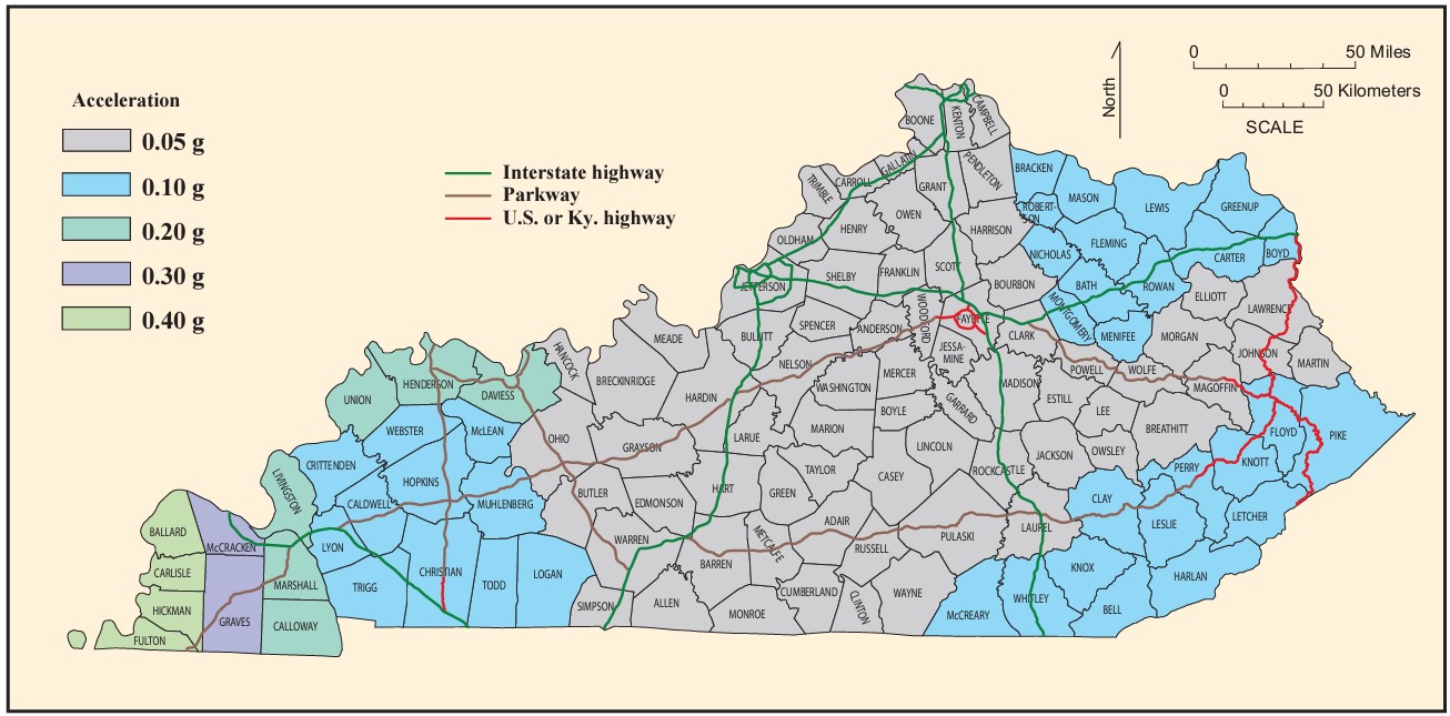
Carpenter, et al. (2014), recommended peak ground accelerations on hard rock for earthquake mitigation considerations in Kentucky (Figure 6). Portions of far-Western Kentucky along the Mississippi and Ohio rivers are expected to see the largest peak ground acceleration values. KYTC District 1, most of District 2, and the southwestern portion of District 3 are expected to see peak ground accelerations on hard rock of 0.10 g or greater. Portions of Northeastern Kentucky (most of District 9 with portions of Districts 6, 7, and 10) and Southeastern Kentucky (portions of Districts 8, 10, 11, and 12) may also see peak ground accelerations on hard rock of 0.10 g. Transportation facilities of critical importance in these areas should be evaluated for seismic issues, and other facilities should also be evaluated depending on the consequences of a facility failing or being placed out of commission.
Kentucky is affected by other natural hazards (e.g., tornados, floods, ice storms) besides earthquakes that may occur more often and present more risk to the built environment. Often the forces that a structure may experience during these events exceed those they would be exposed to from an earthquake. Building and design codes require structures to be constructed to resist forces from these events as well as from other extreme loading cases. Thus, for most areas of Kentucky, designing for these events and loading cases can often help mitigate seismic impacts and require little to no additional mitigation to address seismic hazards. Appropriate site investigations and evaluation by a geo-professional can greatly assist in identifying the risk from an earthquake event.
Figure 6. Peak ground acceleration on hard rock, in units of g (acceleration due to gravity), recommended for mitigation considerations in Kentucky (Carpenter, et. al (2014))
3.4 Mining and Fuel Extraction
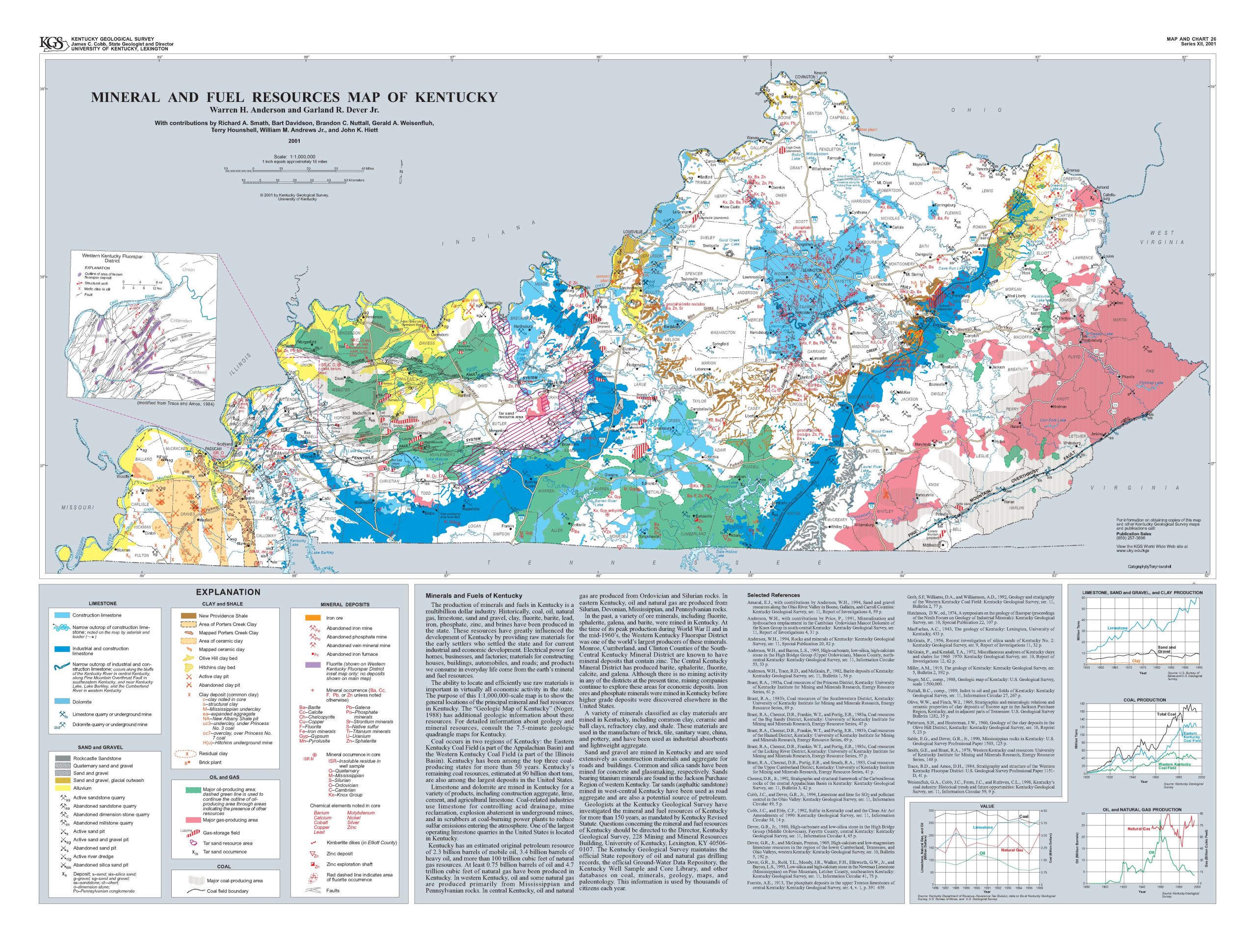
Kentucky’s wealth of mineral and other natural resources has been an important part of the state’s economy and development. Anderson and Dever (2001) produced a map showing the locations of mineral and fuel resources in Kentucky (Figure 7). This map highlights how these resources have influenced the growth and economies of the six physiographic regions.
Figure 7. Mineral and Fuel Resources Map of Kentucky (Anderson and Dever, 2001)
3.4.1 Coal Mining
Kentucky has long been a leading producer of coal in the U.S. Coal, which is found in the Western Kentucky and Eastern Kentucky Coal Fields, is typically extracted through either underground or surface mining. The Kentucky Energy and Environment Cabinet maintains the Kentucky Mine Mapping Information System. This tool can be used to identify areas that have been or are currently being mined and how those areas would impact selection of transportation corridors. It can also help aid in determining how much exploratory drilling may be needed to identify the impacts of mines on the design, construction, maintenance, and cost of a transportation facility.
Hazards related to underground and surface mining include:
- Subsidence or collapse of the mine roof leading to settlement of the ground surface.
- Encountering mines during excavations for roadways, which can lead to collapse of rock cuts and rockfalls.
- Encountering water-filled mines or slurry ponds which can blow out, flood nearby areas, and pollute nearby streams.
- Landslides, settlement, and difficulties constructing structure foundations due to the improper disposal and placement of excavated soil, rock, and spoil materials.
- Sediment runoff and water quality problems.
3.4.2 Oil and Natural Gas
As of 2018, 61 of Kentucky’s 120 counties were involved in oil production, and 31 counties produced natural gas. Oil production in Kentucky peaked in 1960. Natural gas production began to exceed oil production around 1970 and significantly increased in production after 2007. KGS provides an online map service that provides the locations of oil and gas fields, oil and gas wells, and gathering and flow lines.
Encountering wells and/or gathering lines present several problems for transportation facilities. The taking of a well results in a loss of production for the owner, and the value of the lost production can be quite large. Wells and gathering lines can sometimes be relocated but at a cost. Abandoned wells would need to be plugged. There also can be environmental issues and hazardous materials in areas surrounding the wells. The map tools listed above can be used to avoid or assess the impact of taking oil and gas wells.
3.4.3 Limestone and Dolomite
Limestone and dolomite have multiple uses including as construction aggregate, agricultural limestone, lime, and cement. They also can be used to control acid drainage, for mine reclamation, and as scrubbers at coal-fired power plants. Limestone is mined both in open-pit quarries and underground, sometimes with both methods occurring at the same location, with the deeper deposits retrieved by underground mining after the reserves near the surface are exhausted.
Many hazards associated with coal mining apply to open-pit quarry and underground limestone operations. These include subsidence and settlement due to collapse of the mine roof, encountering mine openings in roadway excavations, water-filled mines, and spoil piles from overburden removal or quarry waste. Open-quarry pits can often be filled with water and may need to be refilled with materials or bridged for roadways to cross them. Water-filled quarries may also be considered wetlands and have environmental concerns. If a limestone quarry or mine is active, potential loss of value or production from right-of-way takings may increase project costs.
3.4.4 Sand and Gravel
Sand and gravel are mined in Kentucky primarily for construction materials. Deposits along the Ohio River valley and the major tributaries of the Ohio River have been mined. The Jackson Purchase region has many sand and gravel deposits. Sandstone has also been quarried for various reasons. Hazards related to sand, gravel, and sandstone quarries are like those for limestone quarries, including spoil piles, water-filled pits, and possible wetland issues.
Dredges operate along the Ohio River to obtain sand and gravel. Dredging material from rivers and streams changes the natural stream functions and can result in increased erosion, bank scouring, stream migration, and bottom scouring as the waterway seeks to regain balance. Changes that streams undergo often create hazards for roadways and bridges, including undercutting of adjacent roadways and bridge approaches, scour of bridge foundations, landslides, damage to adjacent property and utilities, localized flooding, and loss of habitat for aquatic organisms.
3.4.5 Clay and Shale
Clay and clay shales have been mined in Kentucky for brick, tiles, ceramics, lightweight aggregate, and pottery. Ceramic and Porters Creek clays are found in the Jackson Purchase region. Porters Creek Clay has been mined for industrial absorbents and kitty litter. The Olive Hill and Hitchens clay beds in the northern portion of the Eastern Coal Fields (Northeastern Kentucky) have been mined in the past for refractory, firebrick, and common brick.
New Providence Shale, which is found in the Knobs region, has been mined to produce brick and lightweight aggregates. Clay from the Irvine Formation in Madison County is mined to produce ceramic earthenware, and other clays from the Borden and Crab Orchard formations have potential for use.
Hazards associated with clay and shale mining are like those for limestone and coal mining in that there may be open pits, spoil piles, and environmental issues.
Porters Creek Clay, which is typically very compact and exhibits a high unconfined compressive strength, causes design and constructability concerns for structures founded on piles. Driving piles through Porters Creek Clay is extremely difficult if not impossible using common pile driving equipment. Earthquake and scour concerns are also relevant in areas where Porters Creek Clay is present, and bridges supported on pile foundations often need a given penetration into the ground to resist earthquake loads or to achieve adequate penetration below scour depths. When piles refuse during driving at a shallower depth on Porters Creek Clay, they may not have achieved adequate penetration to resist earthquake and scour loads. In these cases, pre-drilling piles through Porters Creek Clay may be needed to achieve the required pile lengths.
3.4.6 Other Minerals
Other minerals were mined in Kentucky in the past, including fluorspar, phosphates, and iron. The Western Kentucky Fluorspar District in Livingston, Crittenden, and Caldwell counties was once one of the largest producers of the mineral. Iron ore and their related furnaces were found in areas around Land Between the Lakes and Northeastern Kentucky. Phosphates were mined in Central Kentucky. There is no active mining for these minerals, but there is continued exploration for economically viable deposits. Hazards associated with past mining of these materials are like those for other forms of mining.
3.5 Flooding, Scour, and Stream Migration
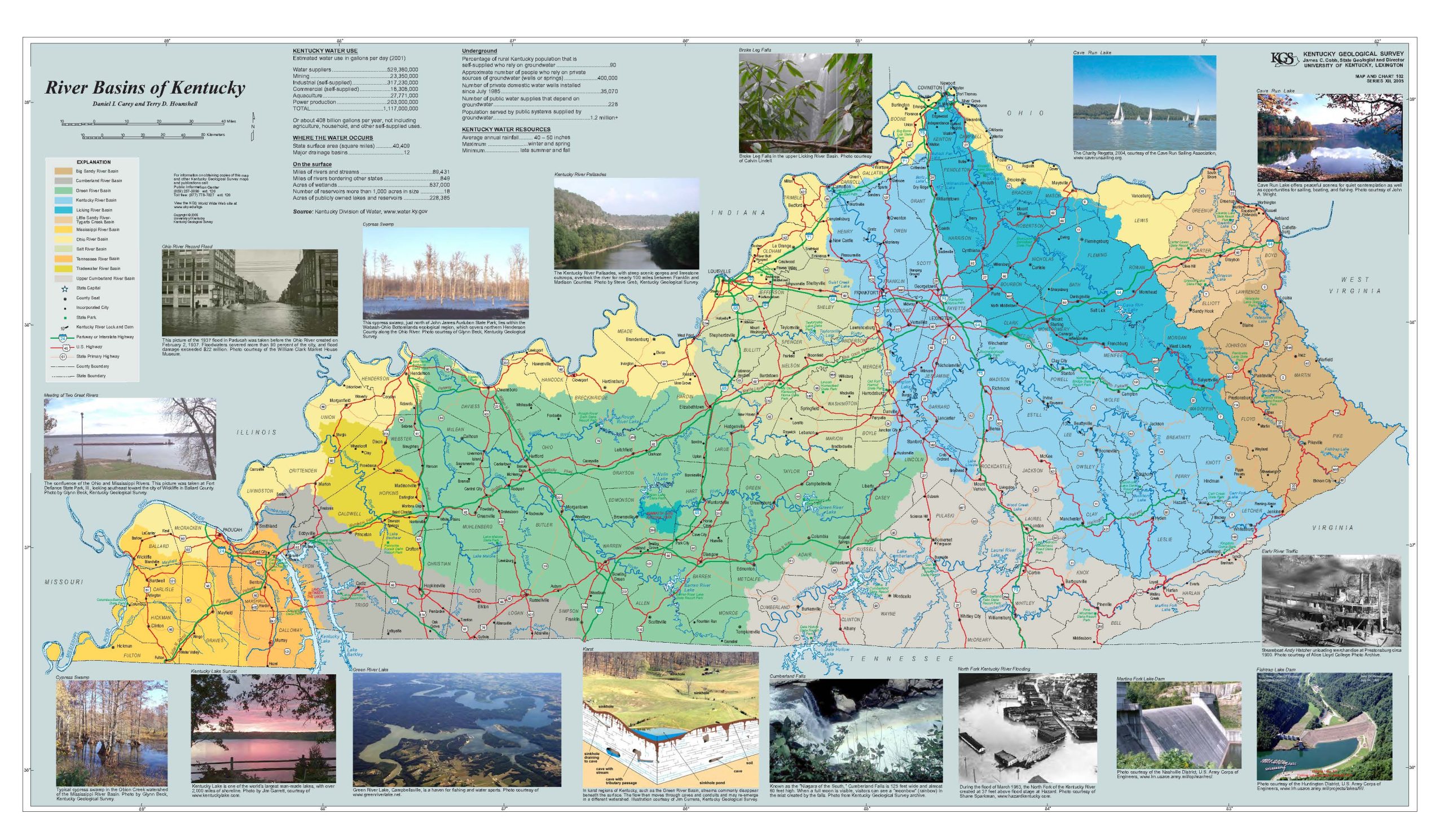
The presence of navigable streams played an important role in the settlement and economic development of Kentucky. These streams, along with the local terrain and geology, also represent significant hazards to nearby properties, including roadways and bridges. Figure 8 shows Kentucky’s major river basins.
Figure 8. River Basins of Kentucky (Carey and Hounshell, 2005)
In areas of the state with more rugged, hilly terrain, precipitation can quickly run off and create flash flooding. Because of the rugged terrain in these areas, most development is in the bottom of valleys along streams. Increased development in these bottomlands exacerbates runoff problems. Runoff can cause streams to quickly overtop their banks, fill surrounding floodplain areas, and overwhelm existing bridges, culverts, and other drainage structures.
In lower-relief terrain and areas with wide, alluvial floodplains, issues can arise with structures that are not sufficiently sized to handle flood flows. In many cases, it is not that the structure was under-designed, but that development and other factors have increased the flood event to levels beyond those anticipated during design.
Geohazards associated with flood events include:
- Scour — Scour is the erosion of soil and rock due to the flow of water. Higher flow velocities, which can occur due to flood events as well as to the restrictions bridge openings place on the floodplain, increase scour. Scour can undermine adjacent roadways and bridge approach embankments. Scour also occurs around in-channel bridge foundations and can remove soil or rock support for piles and spread footings.
- Stream Migration — Streams migrate and meander naturally. As streams migrate some areas are filled with material while other areas have material removed. Flood events speed up that process, and as flood events become more severe stream migration accelerates. Stream migration can also be caused by structures placed in the stream or floodplain that change the path of water flow. Occasionally flood events can even create a new stream channel through avulsions. Stream migration can undermine nearby roadways, bridge approach embankments, bridge foundations, and drainage structures. The outsides of bends in rivers and streams are particularly susceptible to stream migration impacts, and landslides are more frequent at these locations as migration undercuts the toe of the slope.
- Erosion — Increased streamflow velocity during flood events can erode soil and rock leading to scour, stream migration, streambank failure, and landslides. Eroded material is deposited downstream when flows subside, and these areas where the material is deposited can modify streamflow in a way that results in unanticipated scour or stream migration.
To deal with the effects of floods and related scour, stream migration, and erosion impacts, designers can perform the following:
- Appropriately size the bridge or drainage structure — Size the structure to allow the least restriction of the stream and floodplain is one way of reducing the impact. This is often done by use of a design storm (e.g., 100 year) and evaluating how stream stage and velocity respond to the proposed structure. Selecting a design storm implies some level of risk assessment, but it may be appropriate in some cases to further evaluate the risk and select a design storm other than what is typical. An evaluation of current and future land use in the watershed should also be made to assess if runoff changes may occur.
- Evaluate scour potential for bridge foundation and approaches – Bridge foundation locations, sizes, types, and elevations should be selected to minimize the potential for scour-related foundation failures.
- Evaluate historical channel migration — Evaluate historical maps and aerial photographs to determine the direction and magnitude of channel migration. When possible, bridges and roadways should avoid locations where stream migration may occur rapidly. If avoiding those areas is not possible, steps should be taken to design structures or roadways to mitigate the possible future impacts of stream migration. This may include building longer structures to allow the stream to migrate without impacting the structure, more resilient bridge foundations that are not impacted by stream migration, roadways located an appropriate distance away from a stream, or countermeasures to reduce stream migration. However, countermeasures may increase stream migration at other locations along the stream.
3.6 Black Shale
Outcrops of black shales are found throughout the Knobs region. They can also be found in portions of Southcentral Kentucky (Pennyroyal region) extending from Allen County east-northeast toward Casey and Pulaski counties, eventually intersecting with the southern portion of the Knobs region. The area of black shales in Southcentral Kentucky is associated with a low portion (saddle) of the Cincinnati Arch between the Jessamine and Nashville Domes and between the Illinois and Appalachian Basins. This area between the Jessamine and Nashville Domes is also associated with petroleum resources. Black shales can also be found along the Pine Mountain Thrust Fault as Devonian-Age bedrock was pushed up and over Pennsylvanian Age bedrock. Figure 3 shows locations of black shale outcrops.
Black shales are often referred to as Devonian Black shale, Ohio Black Shale, New Albany Black Shale, and Chattanooga Black Shale. Black shales contain enough organic material that they can burn. Fires can start spontaneously in black shales. These fires are thermochemical and difficult to extinguish as water can worsen the problem. Black Shales contain pyrite (i.e., Fool’s Gold), which oxidizes to sulfates when exposed to air and water. Sulfates are sensitive to water and can cause heaving of foundations as well as can produce sulfuric acid. Sulfuric acid can contaminate streams, dissolve limestone used to line ditches and prevent erosion, and damage the concrete and steel of structures.
When black shales are encountered, precautions need to be taken to prevent oxidation of pyrites in rock cuts, in embankment fills, or in excess material disposal areas. This generally involves capping the exposed black shale with two feet of compacted clay. Compacted clay creates a liner that prevents water and air from contacting the pyrite and obstructs the escape of any sulfuric acid produced. Crushed limestone can be used in ditches and other drainage features to help neutralize the acid, but this limestone will likely need to be replenished on a regular basis. Where structure foundations contact black shales, construction specifications should include sulfate-resistant concrete and steel corrosion protection.
3.7 Faults and Dipping Bedrock
The faults shown in Figure 3 represent some, but not all, of the faults across Kentucky. No activity along these faults has occurred in recorded history, and the seismic risk along these faults is low. Seismic risk in Kentucky is generally the result of fault zones outside the state, such as the New Madrid Seismic Zone.
Most bedrock in Kentucky has nearly horizontal bedding, with some minor dipping of bedrock located in areas immediately surrounding the fault zone. The exception to this in Kentucky is the Pine Mountain Thrust Fault in Southeastern Kentucky where strata were pushed up and over underlying Pennsylvanian Age bedrock to create a 120-mile-long mountain.
Geohazards associated with faults are the product of differing bedrock conditions on either side of a fault as well as crushed and deformed rock within the fault zone itself. This can create issues with construction and stability of rock cuts that may pass through the fault. Foundations that may encounter a fault, though rare, can have materials with differing bearing capacities on either side of the fault.
Dipping bedrock impacts rock cut design and bearing of foundation elements. The design of rock cuts in dipping bedrock is challenging and requires careful consideration to provide stable rock cuts as well as to prevent large translational block slides along dipping bedding planes. Foundations on dipping bedrock may encounter materials with differing bearing capacities or erosion characteristics and as such may have special construction requirements.
Early identification of geohazards along a project corridor during the first phases of project development can help project managers understand the impacts of hazards on the project including location, costs, risks, and schedules. Waiting until later in the project development to address geohazards creates fewer opportunities for avoidance and increases the risk of schedule impacts, cost increases, and construction claims. A planning-level geotechnical investigation that identifies potential geohazards within a corridor can help project managers to:
- Evaluate corridor alternatives — Knowing the location of geohazards allows project designers to choose project alignments and grades that may avoid problems.
- Evaluate mitigation options — If geohazards cannot be avoided, project managers can begin to identify mitigation options and determine their impacts on project cost, schedule, right-of way needs, and risk.
- Evaluate potential environmental issues — Where geohazards present potential environmental issues, early identification of hazards, their potential impacts, and mitigation options allow issues to be addressed in environmental documents, agency approvals, and permit applications.
- Evaluate impacts to construction — When unexpected geohazards arise on construction, project schedules and costs are usually negatively impacted. It is important to identify geohazards, specify mitigation methods for those hazards, and inform contractors of these issues to minimize impacts on construction schedules, costs, risks, and claims.
- Evaluate long-term maintenance needs — The frequency and cost of project maintenance can be negatively impacted by not addressing geohazards during the design and construction phases. This includes negative impacts to the traveling public if use of the facility is reduced due to the geohazard.
There is always the potential for unknown hazards to emerge during later stages of project development. But even at these stages, there are opportunities for avoidance or mitigation that can help maintain project schedules, minimize budget impacts, and minimize risks. When unknown geohazards are identified later in project development, additional field work (surveying or geotechnical investigations) may be needed to fully understand the scope and potential impacts of the hazard.
In conclusion, geohazards create risks for project development, costs, schedules, construction, maintenance, and performance if not handled. The earlier in project development geohazards are identified, the more likely their impacts can be addressed and mitigated.
Anderson, Warren H. and Dever Jr., Garland R., “Mineral and Fuel Resources Map of Kentucky,” Kentucky Geological Survey, Map and Chart 26, Series XII, 2001. https://kgs.uky.edu/kgsweb/olops/pub/kgs/mc26_12.pdf
Blandford, Benjamin L.; Schurman, Scott; and Wallace, Candice Y., “Transportation System Vulnerability and Resilience to Extreme Weather Events and Other Natural Hazards — Final Results of Vulnerability Assessment of National Highway System for All KYTC Districts” (2018). Kentucky Transportation Center Research Report. 1594. https://uknowledge.uky.edu/ktc_researchreports/1594
Carey, Daniel I. and Hounshell, Terry D., “Kentucky Terrain,” Kentucky Geological Survey, Map and Chart 182, Series XII, 2008. https://kgs.uky.edu/kgsweb/download/mc187_12.pdf
Carey, Daniel I. and Hounshell, Terry D., “River Basins of Kentucky,” Kentucky Geological Survey, Map and Chart 102, Series XII, 2005. https://kgs.uky.edu/kgsweb/olops/pub/kgs/mc102_12.pdf
Carey, Daniel I.; Hounshell, Terry D.; and Kiefer, John D., “Geologic Hazards in Kentucky,” Kentucky Geological Survey, Map and Chart 185, Series XII, 2008. https://kgs.uky.edu/KGSWEB/OLOPS/PUB/KGS/MC185_12.PDF
Carpenter, N. Seth; Wang, Zhenming; and Lynch, Mike, “Earthquakes in Kentucky: Hazards, Mitigation, and Emergency Preparedness.” Kentucky Geological Survey and the Kentucky Division of Emergency Management, Special Publication 17, Series XII, 2014. https://kgs.uky.edu/kgsweb/olops/pub/kgs/SP17_12.pdf
Paylor, Randall L., and Currens, James C., “Karst Occurrence in Kentucky,” Kentucky Geological Survey, Map and Chart 33, Series XII, 2001. https://kgs.uky.edu/kgsweb/olops/pub/kgs/mc33_12.pdf
Geotechnical Topics Knowledge Book:
Access the complete Knowledge Book here: Geotechnical Topics Knowledge Book
Next Article: Subsurface Investigation Tools and Techniques
Previous Article: Rock Slopes and Rockfalls

