Search for articles or browse our knowledge portal by topic.
Project Development Resources
Contents
1.1 Scoping and Pre-Design Activities
1.2 Purpose and Need Development
1.3 Consideration of All Users
1.4 Planning Studies
3. Preliminary Design & Environmental
3.1 Public Involvement
3.2 Mapping & Survey
3.3 Early Utility Coordination
3.4 Preliminary Right of Way (ROW)
3.5 Traffic Forecasting
3.6 Environmental
3.7 Design Executive Summary
3.8 Roadway Design Parameters
3.8.1 Roadway Construction Types
3.8.2 Design Vehicles
3.8.3 Functional and Contextual Classifications
3.8.4 Design Speed
3.9 Interstate System Guidance
3.10 Design Exceptions and Variances
3.11 Roadway Geometrics
3.11.1 Sight Distance
3.11.2 Horizontal Alignment
3.11.3 Vertical Alignment
3.11.4 Cross Sections
3.12 2+1 Roadways
3.13 Multimodal Facilities
3.14 Roadside Safety
3.15 Intersections
3.16 Interchanges
3.17 Access Management
3.18 Drainage
3.19 Geotech
3.20 Structures
4.1 Computer-Aided Design (CAD)
4.2 Standard Drawings
4.3 KYTC Highway Design Memorandums
4.4 Geometric Design
4.5 Multi-modal Facilities
4.6 Intersection Design
4.7 Interchange Design
4.8 Pavement Design
4.9 Drainage
4.10 Geotech
4.11 Structures
4.12 Traffic Engineering
4.12.1 Traffic Control Devices
4.12.2 Traffic Operations
4.12.3 Traffic Modeling
4.12.4 Transportation Systems Management and Operations (TSMO)
4.12.5 Highway Capacity
4.13 Highway Safety
5.1 Valuations
5.2 Acquisitions
5.3 Relocations
5.4 Property Management
9. Comprehensive Project Development Resources Listing
Project development requires input from multiple disciplines. As such, the project development project manager must consult numerous guidance documents from across the disciplinary spectrum during project development.
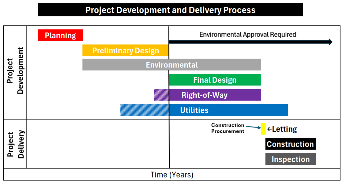
This article highlights the contents of guidance documents project managers are most likely to consult throughout project development. It is organized according to the primary phases of project development and delivery (Figure 1).

Figure 1: KYTC Project Development and Delivery Phases
Most activities described in this section occur during planning, however, some are done as part of preliminary engineering.
1.1 Scoping and Pre-Design Activities
During the early stages of project development, the project need is evaluated and its scope developed. PL-704 and HD-201 review scoping and pre-design activities. The Project Management Guidebook also includes several articles on initiating and scoping projects.
1.2 Purpose and Need Development
A purpose and need Statement succinctly states a project’s purpose (e.g., improve safety, reduce congestion) and why the project is needed (i.e., description of conditions a project will improve [e.g., high crash rates, insufficient capacity]). KYTC has several resources that project managers can use when crafting purpose and need statements:
- HD-202.6.2
- PL-702.2
- KYTC’s Division of Environmental Analysis Project Management website
- Commissioner of Highways memorandum on Purpose and Need Statement Guidance and Instructions
Another resource is the Federal Highway Administration’s (FHWA) Purpose & Need and Alternatives website.
1.3 Consideration of All Users
The KYTC Complete Streets Manual contains strategies and design practices that can be used on any transportation project to promote multimodal safety.
1.4 Planning Studies
Planning studies provide information and scoping parameters for roadway projects. Completed planning studies and Data Needs Analysis (DNA) studies are on the Division of Planning’s website.
Professional Services activities may occur throughout project development. HD-205 discusses the administration of consultant contracts. The HKP Administration of Consultant Contracts Knowledge Book includes multiple articles on selecting consultants and managing contracts.
HD-203 provides guidance on preliminary design activities and decision points.
3.1 Public Involvement
PL-701.2 describes the public input process, while HD-600 provides guidance on public involvement during project development. Section 5.1 of the Kentucky Transportation Cabinet Public Involvement Process also includes information on public involvement in project development.
3.2 Mapping & Survey
HD-300 provides guidance on surveying and mapping.
3.3 Early Utility Coordination
Utility coordination early in project development focuses on identifying utility facilities located in the project area. Consult HD-203.7.3 and UR-500 for information on early utility coordination.
For information on subsurface utility engineering (SUE), review HD-204.5, HD-304, UR-506,and HKP article Subsurface Utility Engineering (SUE).
Most work involved in utility relocations must be initiated after NEPA approval, however, there are exceptions for certain activities. For more information see the HKP article Early Utility Accommodation.
3.4 Preliminary Right of Way (ROW)
Most of the ROW tasks are carried out in conjunction with final design using ROW funding. However, title searches can be started earlier in the process and paid for with Design funding. ROW-300 and ROW-400 provide information on title searches and title reports, respectively.
Preliminary ROW layouts can be developed during preliminary design and are finalized during final design. HD-1300 provides guidance on laying out ROW.
3.5 Traffic Forecasting
Traffic forecasts and special counts (e.g., turning movement counts) are used to determine the number of lanes, evaluate intersection control types, and develop pavement designs. PL-703.6 and HD 202.6.8 provide guidance on traffic forecasting.
If traffic forecasts have been completed, they are usually in the project’s ProjectWise folder. They can also be requested from the Division of Planning’s Multimodal Programs Branch.
KYTC also has Web Maps Page that contains a Traffic Counts map. This map shows KYTC Traffic Count Station locations and the most current Average Annual Daily Traffic (AADT) reports for each site within Kentucky.
3.6 Environmental
HD-400 and the HKP article Project Management and NEPA discuss aspects of the environmental process designers and project managers need to consider during preliminary engineering. An environmental document may include mitigation requirements. KYTC’s Environmental Analysis Guidance Manual provides detailed guidance on the environmental process.
3.7 Design Executive Summary
The Design Executive Summary (DES) is the record of project-related engineering decisions. HD-203.6 provides an overview of information provided in the DES and the approval process.
3.8 Roadway Design Parameters
Designers should select design parameters before developing alignment for each alternative.
3.8.1 Roadway Construction Types
KYTC works on three kinds of roadway construction projects – new, reconstruction, on existing roadways. Chapter 1 of AASHTO’s A Policy on Geometric Design of Streets and Highways (Green Book) describes each type of project.
3.8.2 Design Vehicles
Consult Chapter 2 of the Green Book for information on design vehicles, their characteristics, turning radii, and guidance on selecting an appropriate design vehicle.
Additionally, programs such as AutoTURN can be used in conjunction with OpenRoads Designer to ensure that roadway designs will accommodate the turning radii of different design vehicles.
3.8.3 Functional and Contextual Classifications
Chapter 1 of the Green Book reviews functional and context classifications. The Common Geometric Practices sheets in the Highway Design Manual Exhibits for Chapter 700 summarize geometric design properties by roadway classification.
3.8.4 Design Speed
The Green Book (Chapter 2) defines design speed and provides guidance on selecting design speed based on functional and context classification. HD-703.8 has Kentucky-specific procedures for selecting design speed.
3.9 Interstate System Guidance
AASHTO’s A Policy on Design Standards – Interstate System provides guidance for projects located on interstate highways. FHWA’s interstate access policy website provides information on justifying and documenting new access points or changes in interstate access.
3.10 Design Exceptions and Variances
HD-704 outlines processes for obtaining design exceptions or variances for controlling criteria. HD-203.6 reviews documentation requirements for design exceptions and variances.
Consult FHWA’s Design Decision Documentation and Mitigation Strategies for Design Exceptions when preparing design exceptions and investigating mitigation strategies.
3.11 Roadway Geometrics
This section covers primary design elements, including sight distance, horizontal alignments, vertical alignments, and cross sections.
3.11.1 Sight Distance
Chapter 3 of the Green Book discusses stopping sight distance, passing sight distance, and decision sight distance, while Chapter 9 reviews intersection sight distance.
The Common Geometric Practices sheets in the Highway Design Manual Exhibits for Chapter 700 list minimum stopping and passing sight distances by roadway classification.
3.11.2 Horizontal Alignment
Chapter 3 of the Green Book contains guidance on horizontal alignment elements (e.g., circular curves, spiral curves, superelevation, horizontal sightline offset). HD-702.4 provides guidance on horizontal alignments. KYTC Standard Drawings RGS-001 and RGS-002 address methods of determining superelevation. The Common Geometric Practices sheets in the Highway Design Manual Exhibits for Chapter 700 list values for minimum curve radii by roadway classification.
3.11.3 Vertical Alignment
Chapter 3 of the Green Book reviews elements of vertical alignment (e.g., grades, crest and sag vertical curves, undercrossing). HD-702.8 offers guidance on vertical alignments. The Common Geometric Practices sheets in the Highway Design Manual Exhibits for Chapter 700 list values for maximum grades by roadway classification.
3.11.4 Cross Sections
Chapter 4 of the Green Book discusses cross-sectional elements (e.g., cross slope, lane and shoulder widths, roadside design, curbs, multimodal facilities).
3.12 (2+1) Roadways
A 2+1 roadway is a three-lane highway that has two travel lanes in one direction — one of which is used for passing maneuvers — and one lane in the opposite direction. Whereas truck climbing lanes are added to the roadway where they are needed, 2+1 roadways are continuous three-lane highways with the passing lanes alternating. KYTC’s 2+1 Roadway Design Guidance includes recommendations for 2+1 roadway design and identifies appropriate pavement markings.
3.13 Multimodal Facilities
Reference the following documents when designing multimodal facilities:
- HD-1500
- KYTC’s Complete Streets, Roads and Highways Manual
- AASHTO’s Guide for the Planning, Design, and Operation of Pedestrian Facilities
- AASHTO’s Guide for the Development of Bicycle Facilities
- Pedestrian Right of Way Access Guidance (PROWAG)
3.14 Roadside Safety
AASHTO’s Roadside Design Guide (RDG) and engineering judgment should be used for roadside safety design. HD-800 and the HKP Clear Zone Concepts Knowledge Book summarize key features of the RDG and includes supplemental information.
3.15 Intersections
HD-901 reviews issues to consider during preliminary intersection design.
Intersection control evaluation (ICE) is a data-driven, performance-based framework for screening intersection alternatives and identifying an optimal solution. KYTC’s ICE Policy provides guidance on implementation.
If roundabouts are being considered, the KYTC Roundabout Design Guide provides guidance on roundabout design.
3.16 Interchanges
HD-203.3.10 describes the process of developing an Interstate Access Justification Report (IAJR) (Formerly IJS). For interchanges on interstates, consult FHWA’s Policy on Access to the Interstate System.
KYTC uses Geometric Layout Sheets (GLS) to communicate the geometric features of a proposed interchange for approval by the appropriate KYTC and FHWA personnel. HD-904.8 and HD Exhibit 900-09 provide guidance on Geometric Layout Sheets for interchanges.
3.17 Access Management
HD-1100 reviews KYTC’s access management policies. The Transportation Research Board’s Access Management Manual and the Green Book also includes guidance.
The Kentucky Revised Statutes (KRS 177) and Kentucky Administrative Regulations (KAR 603) also address access management.
3.18 Drainage
Preliminary drainage design must be completed for each alternative prior to the evaluation of alternatives. Most drainage design is performed during final design (see Section 4.9). Drainage design should also be coordinated with the appropriate Drainage Engineer listed in the Highway Design’s Key Contacts website.
3.19 Geotech
GT-201 lists submittal requirements for initiating a geotechnical overview. Geotechnical overviews are needed for situations such as bridges, large excavations and/or fills, rock cuts and construction in karst areas. It is recommended to consult with the Geotechnical Branch early in the project to determine geotechnical needs. Detailed geotechnical investigations usually occur during final design.
3.20 Structures
Preliminary structure design must be completed prior to the evaluation of alternatives. During the preliminary stages of the project, basic information is needed on the size of the structure such as length, width beam depths and foundation type. This information is used to develop cost estimates and to ensure that the structure works well with other design features of the project such as hydraulic openings and clearances. Most detailed structure design is performed during final design (See Section 4.3).
4.1 Computer-Aided Design (CAD)
CADD Standards for Highway Plans establishes standards for submitting electronic files as part of Contract Plans and Proposals.
4.2 Standard Drawings
KYTC Roadway Standard Drawings provide standard construction details that can be used on multiple project types. They are referenced in the construction plan set.
4.3 KYTC Highway Design Memorandums
These memorandums provide updated guidance on project development activities that has not yet been incorporated into guidance manuals. They can be found on KYTC’s website and are organized by year of issuance.
4.4 Geometric Design
The Green Book and HD-701 review geometric design principles, including sight distance, horizontal alignment, vertical alignment, and cross sections. HD Exhibits 700-01 – 700-04 review geometric design practices for different road types. Information on designing low-volume roads is available in AASHTO’s Guidelines for Geometric Design of Low-Volume Roads.
4.5 Multimodal Facilities
The KYTC Complete Streets, Roads, and Highways Manual provides guidance on multimodal design and accommodating all user types. For information on sidewalks, consult AASHTO’s Guide for the Planning, Design, and Operation of Pedestrian Facilities. Pedestrian access requirements are in the Pedestrian Right of Way Access Guidance (PROWAG). Bicycle facility design guidance is contained in the AASHTO Guide for the Development of Bicycle Facilities.
4.6 Intersection Design
Chapter 9 of the Green Book and HD-901 review intersection design. The KYTC Roundabout Design Guide provides guidance on roundabout design.
4.7 Interchange Design
Chapter 10 of the Green Book and HD-904 contain information on interchange design.
4.8 Pavement Design
KYTC’s Pavement Design Guide provides guidance on developing pavement designs for new construction and full-depth reconstruction projects. The KYTC Pavement Design web application can be used for pavement design as well.
4.9 Drainage
KYTC’s Drainage Manual reviews drainage design techniques used by the agency. Many other publications go into more detail on drainage topics. The Drainage Manual contains additional information on these resources.
The KYTC Standard Drawings have many drainage related drawings under the Roadway and Headwall Sections that can be used for drainage design.
4.10 Geotech
GT-202 lists submittal requirements for initiating a geotechnical roadway design investigation, while GT-203 addresses structural foundation investigation instructions. Section 5 of the HKP article Initiating and Understanding Geotechnical Investigations describes how to use Geotechnical Reports.
4.11 Structures
Roadway design often interacts with the design of structures. KYTC’s Structural Design Guidance Manual provides information on the relationship between structure design and roadway design, including pedestrian facilities, drainage, and bridge superelevation.
4.12 Traffic Engineering
Traffic engineering encompasses the planning, design, and operation of traffic control devices, streets and highways networks, adjacent lands, and interactions with other modes of transportation and their terminals.
4.12.1 Traffic Control Devices
FHWA’s Manual on Uniform Traffic Control Devices (MUTCD) governs the use and placement of traffic control devices on roadways. Another resource for signing plans is the Standard Highway Signs publication. The KYTC’s Standard Drawings Traffic series is helpful when laying out striping, pavement markings, and rumble strips.
4.12.2 Traffic Operations
Project development teams should consult KYTC’s Traffic Operations Guidance Manual when working through aspects of projects that affect traffic operations.
Traffic Operations Guidance Memos describe policies that have not yet been included in the Traffic Operations Guidance Manual. Typically, this guidance is incorporated into the guidance manual’s next update.
4.12.3 Traffic Modeling
KYTC’s Microsimulation Guidelines provide a framework for conducting traffic microsimulation analysis.
4.12.4 Transportation Systems Management and Operations (TSMO)
TSMO encompasses strategies for optimizing the safe, efficient, and reliable use of existing and planned multimodal transportation infrastructure. KYTC’s website includes the TSMO plan, project and case studies, and fact sheets.
4.12.5 Highway Capacity
The Highway Capacity Manual (HCM) presents methods for quantifying highway capacity for different types of roadways, intersection traffic control methods, and corridors.
4.13 Highway Safety
KYTC’s Data Driven Safety Analysis (DDSA) Implementation Plan (login required) employs evidence-based models to quantify safety impacts. It applies a data-driven approach to identify high-risk roadway features and improve safety, decision making, and investment decisions.
AASHTO’s Highway Safety Manual (HSM) offers valuable safety information and tools to help practitioners make decisions related to safety performance. AASHTO’s Roadside Design Guide provides guidance on aspects of roadside safety, including clear zones, roadside barriers, end treatments, and other roadside features.
The Access Management Manual provides guidance on applying access management principles and different access management techniques.
ROW tasks begun during preliminary design (title work and preliminary layouts) are built upon to refine the proposed ROW limits and costs. ROW funding pays for these tasks.
5.1 Valuations
KYTC must determine the value of each parcel in the proposed ROW for a project to determine the fair market value. ROW-600 and the Appraisal Guidelines Manual describe appraisal methods.
5.2 Acquisitions
KYTC must acquire parcels through negotiations based on just compensation. ROW acquisition and relocation assistance activities must comply with 49 CFR Part 24 and 23 CFR Part 710. ROW acquisitions are covered in ROW-700.
5.3 Relocations
Relocation refers to the process of moving individuals, families, businesses, or farms from real property due to a highway project. The Relocation Assistance Program helps individuals and entities impacted by a project relocate in a fair, cost-effective manner. ROW-805-2 and the Relocation Assistance Guidance Manual offer guidance on relocations.
5.4 Property Management
Property management refers to the oversight, operation, control, maintenance and/or removal of real-property improvements and structures acquired through the ROW process. ROW-1100 discusses property management.
Utility coordination efforts started during preliminary design continue throughout final design. Some facilities may need to be relocated. Information on utility coordination and relocation can be found throughout the Utility and Rails Guidance Manual. Utility relocation plans can also be included in the roadway contract (See UR-1700).
If a project could potentially impact a railroad, KYTC and the railroad company must coordinate. UR-2000 discusses the railroad coordination program.
Utility and Rail coordination activities are managed by the Kentucky Utility and Rail Tracking System (KURTS). KYTC’s utility coordination website has KURTS-related resources, including training videos.
CP-301 provides guidance on preparing proposals and the bidding process. An important component of this process is preparing project estimates using previous KYTC bidding information. The Division of Construction Procurement maintains spreadsheets that contain historical unit bid prices on the KYTC Average Unit Bid Prices page.
HD-210 details the responsibilities project managers assume during construction.

